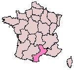
This map outlines all the regions in France. Languedoc-Roussillon is the region which is highlighted.
As a student I found that going to a different country for a field trip was quite daunting. So on my return I decided to put together this website to enable other students travelling to the Languedoc-Roussillon region, for a geology field trip, to use this 'Virtual Field Trip' to give themselves a head start and to gain some very basic knowledge of the area. However this website does not give you all the answers as it is not intended as a replacement for the real thing. It will mean doing some work of your own for example: descriptions of lithologies and structures. I decided to specifically dedicate this website to the volcanics of the region with links to outside websites containing information about other aspects of the geology of the region.
France is made up of a number of regions. (Map 1)
Map 1:
|
|
This map outlines all the regions in France. Languedoc-Roussillon is the region which is highlighted. |
| Map courtesy of Renater. (This image has been reproduced with permission.) |
Languedoc-Roussillon is situated in the south of the country. This region stretches from the 'Massif Central' in the north and ends at the Mediterranean in the south. (Map 2)
Map 2:
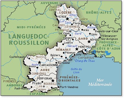
|
|
This map focuses in on the Languedoc-Roussillon region. Map courtesy of AFG. |
To many this region is considered to be made up of just limestone. However, it also has a lot of volcanics and some very complex geology. This website is designed to give a basic understanding of the young volcanoes and volcanic rocks of the region and hopefully provide the reader with some useful information.
The Chaîne des Puys is a series of volcanoes which form the northern part of a chain down the middle of France. This chain of volcanoes starts in the Massif Central and ends at the Mediterranean. This chain consists of over 100 volcanoes with the most famous being 'Puy de Dôme' within the Chaîne de Puys.
Map 3:
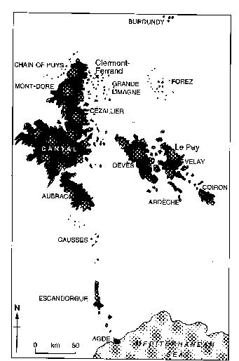 |
The young volcanic rocks of central and southern France |
Image courtesy of Alwyn Scarth and Jean-Claude Tanguy.
Map 4 shows St. Thibéry and its location to the Mediterranean.
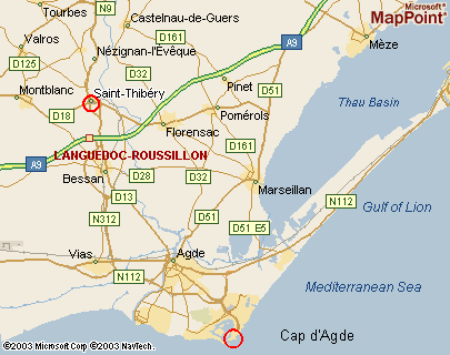 |
Map showing St. Thibéry and Cap d'Agde in relation to the Mediterranean Sea |
This Virtual field trip is intended to allow the reader to view the volcanic region of Languedoc-Roussillon without actually having to go there. However, it is not intended to replace the actual experience which would be gained from visiting such an area. The reader should navigate through the 'Virtual Field Trip' by visiting the locations (listed below). There is no particular order to which locations should be visited.
http://www.volcanogeol.com/agde/capagde.htm Complexe volcanique du Mont Saint Loup, Cap d'Agde (France), by Alain Guillon. A comprehsensive and well-illustrated description (in French) of the Cap d'Agde volcanoes.
Languedoc geology Clear to understand. The links are good and useful. This is a good website for information about the Languedoc-Roussillon field trip
http://volcano.oregonstate.edu/chaine-des-puys A brief description of the Chaîne Des Puys. One single page therefore no navigation problems.
http://www.enjoyfrance.com/places-to-go/massif-central-2011-12-08-4506.html This website contains a brief overview of the Auvergne region. Easy to navigate. A nice simple website.
http://www.afg-2000.org/manuel_genealogie/organisation_territoriale/metropole/languedoc-roussillon.html This website is also in French, but it was easy to navigate with little knowledge of French. The design is plain and simple which means it doesn't detract from the information contained within the site.
From p. 201 of Volcanoes of Europe, by Alwyn Scarth & Jean-Claude Tanguy (Terra Publishing, 2001; reproduced with permission)
http://mappoint.msn.com/(iwy1brfvktj10hfq2fblds45)/map.aspx?L=EUR&C=43.39524%2c3.41485&A=41.56667&P=|822D70|&TI=Saint-Thib%c3%a9ry%2c+H%c3%a9rault%2c+Languedoc-Roussillon%2c+France This website is a map finder. It is slow to load. It is useful for finding maps all round the world.
http://www.infoplease.com/ipd/A0334737.html This is an online dictionary. It is useful to obtain meanings of words. Easy to use.
Web site written by: Suzanne Moore. Additions by Roger Suthren. About this site
Last Modified: Tuesday, June 4, 2013 21:39