Virtual Field Trip
to the Carbonate Sediments of the Florida Keys
Contents of this page: View from Space | Introduction
to the Trip | Introduction to the Florida Keys
| Start the Trip
|
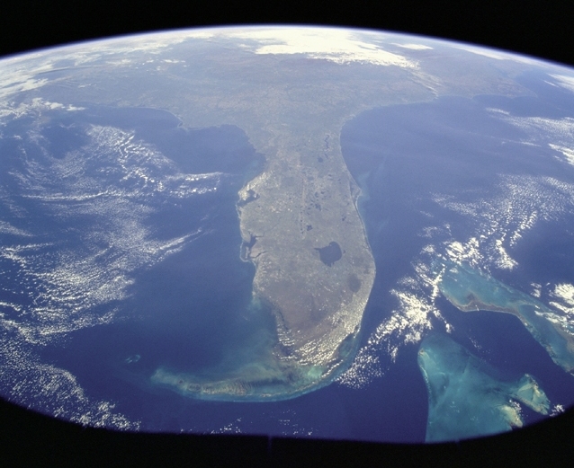
Photograph from space shuttle Discovery. Image
and caption information courtesy of NASA.
[Note added February 2003: Many of the images included
in NASA's databases were taken by astronauts flying on space shuttle missions.
I would like to pay tribute to the huge contribution to the earth sciences
made by shuttle astronauts over the years, through the data and images
they have gathered. The recent Columbia tragedy illustrates the risks
taken by these brave men and women in the cause of science.]
Move the cursor over the image to see an explanation
of the features shown.
"Taken during the STS-95 mission from a point over Cuba, this
photo shows an oblique, foreshortened view of the Florida Peninsula, with
the light blue, shallow seafloor of both the Florida Keys (curving across
the bottom of the view) and the Bahama banks (right). 'Popcorn' cumulus
cloud covers Miami and the Southern Everglades... Lake Okeechobee is the
prominent waterbody in Florida. Cape Canaveral is shown well, half way
up the peninsula. Orlando appears as the lighter patch West (left) of
Cape Canaveral, near the middle of the peninsula."
Much of the low-lying peninsula is made of Tertiary to recent marine
limestones. In the Everglades and the Florida Keys, Pleistocene limestones
form the bedrock, which is often exposed at the surface. Modern carbonate
sediments form a veneer which is generally a few millimetres to a few
metres thick, over the limestone bedrock. Thus, the bedrock plays a strong
part in determining the distribution of modern facies.
|
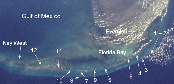
Above is an annotated enlargement from the Space Shuttle
image of the Florida Keys above. Image courtesy of NASA.
Approximate positions of numbered locations are shown: click on the
number or arrowhead to go to the location.
|
Introduction to the Virtual Field Trip
The purpose of this virtual field trip is to introduce you to an example of
modern subtropical shallow marine and coastal environments, in which calcium
carbonate sedimentation is dominant. It is designed to be used by by students
of geology, oceanography, physical geography and environmental sciences, and
uses images as an important learning tool.
Locations are grouped into five areas: the Upper, Middle and Lower Keys, with
side trips to Florida Bay and the Everglades. You may visit the locations
in any order. Each location page contains a number of small ('thumbnail') images.
To complete the trip, you should visit each of the images from that location.
However, for a quicker tour of the main environments and processes, you may
concentrate on the highlighted thumbnail images, usually two or three for each
location. For each image, there is some accompanying text. You should make notes
on the images and text, just as if you were there in the field. Some images
have questions for you to think about, to help you to understand what you are
observing, and to give you feedback on your observations. Questions are indicated
in the web pages as follows:
 |
Where are the Florida Keys? |
This web site is still under development, and additional information, images
and exercises will be added to it.
A glossary of some of the
more commonly used terms is provided.
Introduction to the Florida Keys
Natural features
The Florida Keys are a chain of Pleistocene carbonate islands some 200 km long,
which extend from Key Biscayne (south of Miami), in the northeast, to Key West,
in the southwest. Modern sediments are almost entirely calcium carbonate.
|
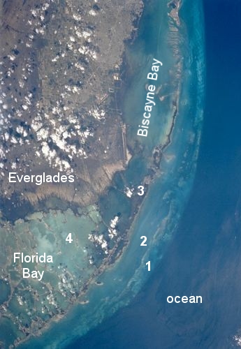
Image courtesy of NASA
|
There are various ways of subdividing the Keys into physiographic zones.
A simple subdivision is:
- A reef tract in the SE, which shelves off steeply into the
deep water of the Florida Straits. The reef rarely emerges above low-tide
mark, so it may not be strictly correct to refer to it as a barrier
reef
- A back reef lagoon with various carbonate mud and sand facies,
on the ocean side of the Keys
- The islands of the Keys: exposed Pleistocene limestone, mangrove
swamps, beaches and bays
- Florida Bay (and Biscayne Bay in the north):
this is really part of the back-reef lagoon, but separated from the
oceanward part of the lagoon by the islands of the Keys. Predominantly
low-energy carbonate muds, with banks and islands of mud emerging above
sea level.
|
Climate
The Florida Keys lie in the sub tropics, between 24° 33' north (Key West)
and 25° 48' north (Miami). The climate is warm all year round, with most
rainfall concentrated between May to October. See climate data for Miami
and Key West
- note that temperatures are in degrees Fahrenheit, and rainfall in inches.
This area is frequently subject to tropical storms and hurricanes from spring
to autumn. These very high energy events are responsible for high rates of sediment
erosion, transport and deposition, and drastic modification of environments
and ecosystems. See, for example, the map
of 2001 tropical storms, and the maps for 1998,
1999
and 2000.
|
How many tropical storm (T.S.) and hurricane
(Hur.) events affected the Florida Keys during the years 1998-2001? Make
a list of the events and the dates they occurred. Further information: |
|
What were the effects of these events in the
Keys? Search the Web for information
on one
of the hurricanes and its effects. |
Human influence
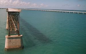 |
The islands have been artificially joined by bridges and causeways. These
first carried a railroad, destroyed by a hurricane in 1935, and then a road:
this is the southernmost part of US Highway 1, known as the Overseas Highway.
Places and addresses are conveniently referred to by 'mile markers' - mile
marker 0 is in Key West, and mile marker 107 is on the bridge joining Key
Largo to the mainland. Locations on the south side of the highway are referred
to as ocean side; those to the north, on the edges of Florida Bay,
are bay side. |
Much of the natural landscape of the Keys has been modified or destroyed by
development. In recent years there has been more protection of natural resources,
but there are heavy pressures brought about by the main industry of the Keys:
tourism. Effects of development and tourism include:
- destruction of natural habitats for building
- pollution of the ocean and the bay
- boat traffic damaging fragile shallow-marine ecosystems such as seagrass
beds, reefs and mangrove swamps
- restriction of tidal current flow by bridges and causeways
- introduction of exotic plant and animal species
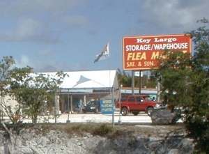 |
At times, driving along Highway 1, particularly in the Upper Keys, and
ignoring the palm trees and other signs of the sub tropics, you could be
almost anywhere in suburban North America: the scene is dominated by tacky
strip malls, shopping centres, gas stations, billboards, motels, condominiums
and other unattractive manifestations of urban sprawl. |
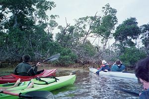 |
Off the main highway, though, there are still substantial areas of wilderness
and semi-wilderness to be explored on foot, by boat, or by snorkelling or
diving. Access to the shoreline, much of which is privately owned, can be
a problem. It is most easily accessed in the various state parks, which
have excellent interpreted walking trails and canoe trails, and organized
trips to view the reefs by snorkelling, diving or from a glass-bottomed
boat. |
Start the Virtual Field Trip
Now proceed to one part of the Keys or to an individual location selected
from the list below:
Content and design by Roger Suthren. Last updated
29 March, 2021 13:10