virtual-geology.info

Energy
from Water
GEOTHERMAL
ENERGY RESOURCES
 |
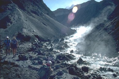
Hot stream flowing
from the crater area, Mount St Helens. Photo by Roger Suthren
|
Definitions
geothermal gradient
is the vertical change of temperature with depth, measured in degrees Kelvin per
kilometre, °K km-1
units of geothermal
heat flow are Joules per square metre per second, Jm-2s-1.
However, one Joule per second = 1 Watt (W), so that heat flow is usually expressed
as Wm-2, or more conveniently, mWm-2 (milliwatts per square
metre).
- The above metric units
replace the heat-flow unit (HFU), which is still in common usage in North
American literature
- 1 HFU = 1 cal cm-2s-1
(1 calorie per square centimetre per second).
- For conversion purposes,
1 HFU = 41.8 mWm-2
Heat flow is determined
by measuring geothermal gradient in a borehole and thermal conductivity of the
rock drilled.
Heat sources for
geothermal energy are:
- Conductive heat from
the mantle
- Heat generated in the
crust by decay of radioactive isotopes of U, Th and K
- Shallow magma bodies
acting as local heat sources
Classification of areas
of the earth's surface, according to geothermal potential:
- non-thermal areas,
geothermal gradient 10 to 40 °K km-1
- thermal areas semithermal
areas, geotherm up to 70 - 80 °K km-1
- hyperthermal areas,
geotherm many times greater than in non-thermal areas
Promising areas for geothermal
exploration are associated with one or more of these indicators:
- recent volcanic activity
- frequent seismic activity
- high level of conductive
heat flow
- hot springs, geysers
or fumaroles
Requirements for a hydrothermal
field
- heat source - often
magmatic, resulting in high geothermal gradient
- bedrock layer - more
or less impermeable
- aquifer/reservoir -
permeable, fractured, providing heat exchange surface of large surface area
- source of water replenishment
(recharge)
- caprock - impermeable
seal and thermal insulator (often formed by 'self-sealing' )
Links
to information sources on the Web
Below
are just a few of the thousands of links to geothermal energy information on
the Web.
General
Geothermal Exploration
Online books
Geothermal
resources by region
Iceland
USA
Applications
of Geothermal Energy
Consequences
of Geothermal Exploitation
Selected
references on geothermal energy
Books:
- ------. 1988. Drawing
heat from the earth: geothermal energy technology in Britain. Department of
Energy, London.
- ------. 1982. Investigation
of the geothermal potential of the UK. - A review of data relating to hot
dry rock and selection of targets for detailed.... Institute of Geological
Sciences, London.
- ARMSTEAD, H.C.H. (ed.).
1973. Geothermal Energy, Review of Research and Development. Unesco.
- ARMSTEAD, H.C.H. 1983.
Geothermal Energy. 2nd edition. E & F.N. Spon.
- DICKSON, M.H. and FANELLI.
M (eds). 1995. Geothermal energy. Chichester, Wiley.
- DOWNING, R.A. And GRAY,
D.A. (Eds.). 1986. Geothermal energy : the potential in the United Kingdom.
London, H.M.S.O.
- EDWARDS, L.M., CHILINGAR,
G.V., RIEKE, H.H. & FERTL, W.H. (Eds.) 1982. Handbook of Geothermal Energy.
Gulf Publishing Company.
- ELDER, J. 1981. Geothermal
Systems. Academic Press.
- GALE, I.N. 1984. Investigation
of the geothermal potential of the UK. - An assessment of the geothermal resources
of the United Kingdom. British Geological Survey, London.
- KELLAWAY, G.A. (Ed.).
1991. Hot Springs of Bath. Investigations of the Thermal Waters of the Avon
Valley. Bath City Council.
- RINEHART, John S. 1980.
Geysers and geothermal energy. New York, Springer-Verlag.
- RYBACH, L. & MUFFLER,
L.J.P. 1981. Geothermal Systems: Principles and Case Histories. John Wiley
& Sons.
Periodicals:
- Journal of Volcanology
and Geothermal Research.
Videos:
- ------. 1981 The Earth
[Videorecording] : structure, composition [and] evolution. [Programme 9] :
Geothermal energy. Milton Keynes : Open University. (Science : a second level
course).
- ------. 1996, S268 Physical
Resources and Environment. [Programme 6] : Renewable Energies. Milton Keynes:
Open University.
Case
Studies
YELLOWSTONE
GEOTHERMAL AREA, WYOMING/MONTANA/IDAHO, U.S.A.
 |
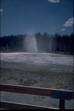
Porkchop
Geyser, Yellowstone, in 1989. Since this time, a large steam explosion has
destroyed the geyser. Photo by Roger Suthren |
Geology:
- high volcanic plateau
in a region of active major crustal extension, probably related to hot spot
migration.
- active volcanism for
at least the last 2.2 Ma
- predominantly rhyolitic,
with subordinate basalts
- 3 major silicic eruptions
associated with caldera collapse and voluminous ash-flow sheets at
- 2.0 Ma (collapse
of 30 km diameter caldera, 2500 km3 ash flows)
- 1.3 Ma (250 km3
ash flows)
- 0.6 Ma (900 km3
ash flows)
- Composite caldera 70
x 45 km
- New influx of magma
and resurgent doming from about 150,000 B.P
- large, shallow silicic
magma body:
- ?45,000 km3
- total heat content
of 1.125 x 10²³J, or 2.687 x 10²² cal
- responsible for much
of present hydrothermal activity
- latest eruption ca.
70,000 BP (rhyolite lava)
Geophysics:
A variety of geophysical
anomalies coincide with the 0.6 Ma caldera:
- T greater than 350°C
at very shallow depths
- low density
- large convective and
conductive heat flow
- magnetic low
- low seismic velocities
- high seismic attenuation
- lack of earthquake
foci deeper than 3-4 km beneath caldera
- sharp increase in electrical
conductivity at ca. 5 km depth
- historical record of
inflation and deflation
All this indicates that the
magmatic system is still active, and that magma underlies much of the caldera
at 5-10 km depth (as little as 3 km in the east?).
The hydrothermal system:
- recharge from meteoric
waters from precipitation mainly on mountains to N and NW
- waters convect to depths
of 4-5 km within caldera, reaching max. T of 350-430°C
- convective heat discharged
by the system is ca. 1.7 x 10¹⁷J yr-1
- 20% increase in heat
discharge in 1983, year before the Mt. Borah earthquake
- activity has occurred
at this level for at least the last 15,000 years
- is system cooling down
or heating up?
- thermal energy from
cooling of already crystalline rocks, from crystallizing magma, or both
- recent uplift suggests
injection of new magma and/or liberation of fluid from crystallizing magma
- most hydrothermal activity
occurs within the 0.6Ma caldera, close to ring fracture or at margins of resurgent
domes, also along N-S fault system (e.g. Norris, Mammoth)
- reservoirs mainly permeable
rhyolite flows at various depths, sandwiched between impermeable ash-flow
tuffs
- in W part of Park,
hot water systems dominate
- eastern systems are
vapour-dominated (fumaroles, mudpots etc.)
- reservoir T ranges
from 180 to 270°C
- springs emerge where
faults cut basins
- most springs are neutral
to slightly alkaline, and deposit siliceous sinter
- no exploitation of
geothermal resources is likely in America's largest National Park
References: FOURNIER,
R.O. 1989. Geochemistry and dynamics of the Yellowstone National Park hydrothermal
system. Annual Review of Earth and Planetary Sciences, 17, 13-53.
VALLES
GEOTHERMAL AREA, NEW MEXICO, USA
 |
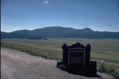
View
of part of the Valles Caldera, New Mexico, showing the large resurgent dome
where much hydrothermal activity is located. Photo by Roger Suthren |
Geology:
- occurs at the boundary
between the Colorado Plateau and the extensional Rio Grande Rift
- in the Rift, high heat
flow is concentrated towards the W margin: highest heat flow values 250-670
mWm-2
- closely related to
Quaternary volcanic centres
- thus, local large igneous
source is superimposed on large regional zone of high heat flow
- volcanism in Jemez
Mts more or less continuous for the last 13 Ma, with a peak ca. 1.1 Ma ago
(major ash flow eruptions)
- bimodal basaltic/silicic
volcanism, with magma chamber >>3km depth
- Valles is a resurgent
caldera
Hydrology:
- recharge from streams
fed from perched water tables in near-surface volcanic and sedimentary rocks
- some recharge from
deep-seated geothermal waters
- springs occur either
at intersections of perched water table with topography, or where there is
upward movement of water along faults
The geothermal/hydrothermal
system:
- within the caldera
is a high T hydrothermal system
- main resource is a
liquid-dominated, underpressured system
- T up to 330°C
- surface expression
is hot springs, fumaroles and rock alteration.
- production mainly from
fractures in pumice-rich basal 300m of Bandelier Tuff
- wells 1500m to 2700m
deep
- graben faults very
important in controlling movement of hydrothermal fluids
- as they move down the
hydraulic gradient, hot fluids cool and mix with colder ground waters, resulting
in low enthalpy systems
- low T hydrothermal
systems within the Jemez Mountains are exploited for balneology (look it up!)
and small-scale space heating
The hot dry rock system:
- W of Valles is hot,
dry rock of low permeability
- at Fenton Hill, two
3 km deep holes have been drilled, reaching T of ca. 200°C
- holes connected by
hydraulic fracturing to produce heat exchange surface
- low water loss so far
- in 2nd test, depth
of 4 km and T of 250°C reached
- heat reservoir is impermeable
Precambrian basement.
References:
- GOFF, F. & GRIGSBY,
C.O. 1982. Valles caldera geothermal systems, New Mexico, USA. Journal of
Hydrology, 56, 119-136.
- GOFF, F., SHEVENELL,
L., GARDNER, J.N., VUATAZ, F.D. & GRIGSBY, C.O. 1988. The hydrothermal
outflow plume of Valles Caldera, New Mexico, and a comparison with other outflow
plumes. Journal of Geophysical Research, 93 (B6), 6041-6058.
- HEIKEN, G., GOFF, F.,
GARDNER, J.N. And BALDRIDGE, W.S. The Valles/Toledo Caldera Complex, Jemez
Volcanic Field, New Mexico. Annual Review of Earth and Planetary Sciences,
18, 27-53.
- Resurgent
Calderas and the Valles Caldera
- Jemez
volcanic field & Valles Caldera, New Mexico
- Geothermal
potential of Valles Caldera (pdf)


This page is maintained
by Roger Suthren. Last updated
2 December, 2021 4:06 PM


![]()