Location 6
Namib Desert
Source: NASA
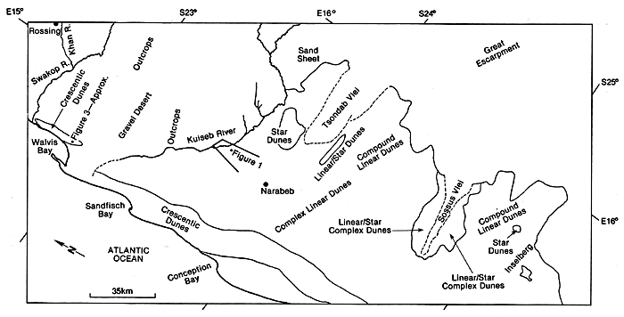
The Namib Desert is situated in South Africa and is one of two deserts in the South the other being the Kalahari. It is known as a coastal desert with its main topography being gravel plains. It covers the countries Angola, Namibia and South Africa. The map above shows the locations of the different types of dunes found over the Namib Desert. The dunes in the namib are of the highest in the world being some 800ft in areas. There are 3 main dunes found in the Namib desert, described by Lancaster 1983. He describes a 5-30 km wide zone of compound coastal crescentic dunes. Crescentic dunes are common in coastal deserts with prevailing onshore winds.
 |
The morning sea fog is common in coastal deserts and moistens the dune.The crescentic dunes are in the centre of the image. |
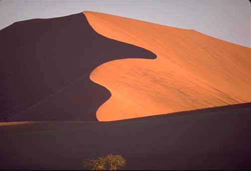
The linear dunes are formed inland of the crescentic dunes as 3-5 sinuous ridges, 5-10 metres high and spaced at 1.5-2km apart.
 |
80-100metres tall linear dunes of the Namib sand sea. |
In the Namib Desert there are many features found, both Aeolian erosional landforms and features and also depositional. The erosional processes involves deflation and abrasion.
Features found in Namib desert:
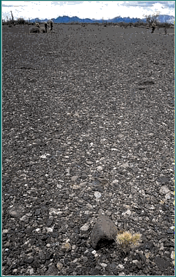
Gravel Lag Deposits - this includes gravel or coarser deposits on the surface of the desert. It is suggested that a high proportion of deserts are covered by lag deposits and not sand. This is the case in the Namib desert.
 |
Formed by erosion and then blown by the wind. Source: University of Melbourne |
Ventifacts- These are pebbles or cobbles that have been abraded by dust and silt. Facets are then produces at angles between 30 and 60 degrees facing the prevailing wind. If three of the pebbles sides are abraded then this can cause a pyramid shape, known as dreikanter. The presence of the driekanter pebble can indicate that there is a multi-directional wind regime, but they can also be produced from a uni directional wind flow.
Ripples- These are a depositional landform and are wave like undulations orientated at right angles to the direction of the prevailing wind. R.A. Bagnold put forward a theory for the formation of ripples, as particles hit the shallow stoss side it dislodged particles on the crest and cause them to fall down the lee side. This meant that the ripples also migrated. The ripples are common in the Namib desert in Namibia, at Walvis Bay. They are well sorted and therefore regular shaped ripples.
 |
These are seen in the southern Namib Sand Sea as mega dune (or draa) scale from landsat imagery. These are very large dunes. Source: Courtney Milne |