| home | virtual field trips | regional geology | images | e-learning | links |
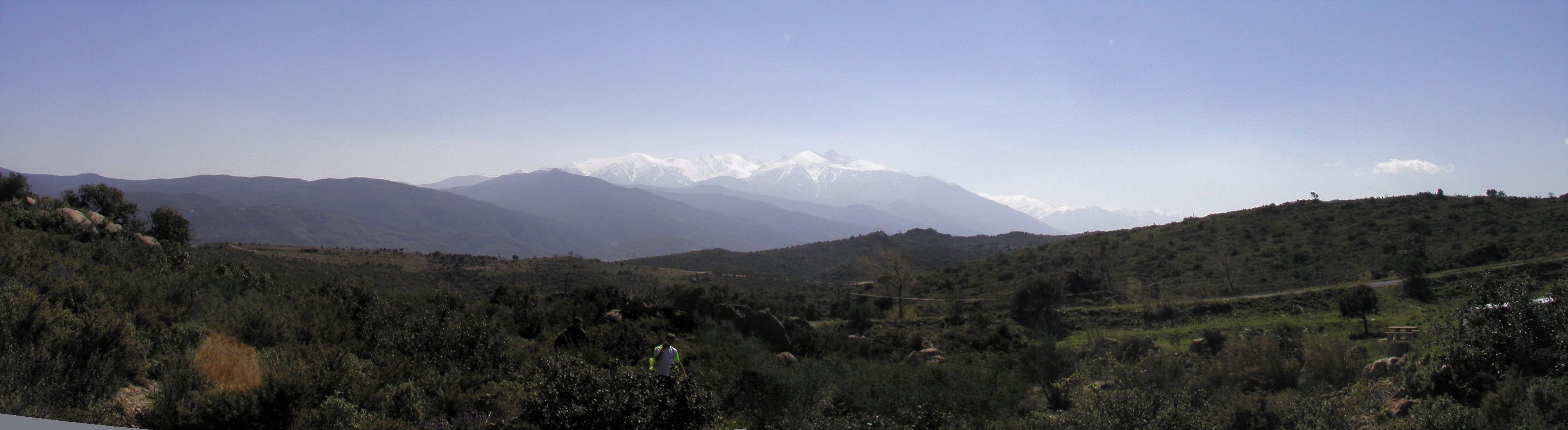
View south across the Axial Zone to the Canigou Massif, culminating in snow-topped Pic du Canigou (2,784m)
This web page provides further information on the localities described in the article “Classic localities explained: The Eastern French Pyrenees from Mountain Belt to Foreland Basin” by Dorothy Satterfield, Hugh Rollinson and Roger Suthren, (Environmental Science, University of Derby, Kedleston Road, Derby, UK. DE22 1GB) published in Geology Today in November/December 2019.
Printable
pdf version of this web page
The localities described in the article are shown on a Google Earth map which can be downloaded by clicking here. If the file doesn't open, right click the link, save the file and open it in Google Earth. The file includes parking and other logistical information. Sub-localities such as 5a, 5b refer to the Google Earth file.
Localities are ordered roughly from S to N, from the core of the Pyrenean mountain belt to the Aquitaine-Languedoc foreland basin and then to the Variscan foreland, although this may not be the most convenient order in which to visit them. The Geology Today article contains more information on the geology. Click on the images to enlarge them.
The file can also be viewed on the web in Google Maps:
All the published geological maps from BRGM (the French Geological Survey) may be viewed in Google Earth by downloading files from their web site. If you have this file visible as a layer in Google Earth, you can see the excursion locations superimposed on a geological map. Locality 5 (and some additional localities to be added later) are on 1:50,000 map sheets which have not been published.
At these localities the rocks of the older Variscan basement of the former Iberian plate are exposed, reactivated during the Pyrenean collision.
One of the most enjoyable ways to see this area, from the high intermontane basin of the Cerdagne to the Conflent Valley is on the Train Jaune (Yellow Train), a narrow gauge line which is part of the national SNCF rail system. It runs from Villefranche-de-Conflent, inland from Perpignan, to Latour-de-Carol, high in the Pyrenees: more info . Several of the stops are at small spa towns which have grown up around warm springs.
Locality 1.
The Mont-Louis Granite - near Via (D29 road cutting at 31T 0422283 4704130)
Google Maps
There are numerous outcrops of the late Variscan Mont-Louis-Andorra pluton in
the area around Col de la Perche. This locality is on the D29 towards Via, about
500m W of the junction with the N116. Park vehicles in the layby next to outcrop.
There is room for a coach. Fresh granite with dark xenoliths. Stretched xenoliths
are seen in 3D.
Another feature of interest nearby is the solar furnace at Odeillo: link.
 |
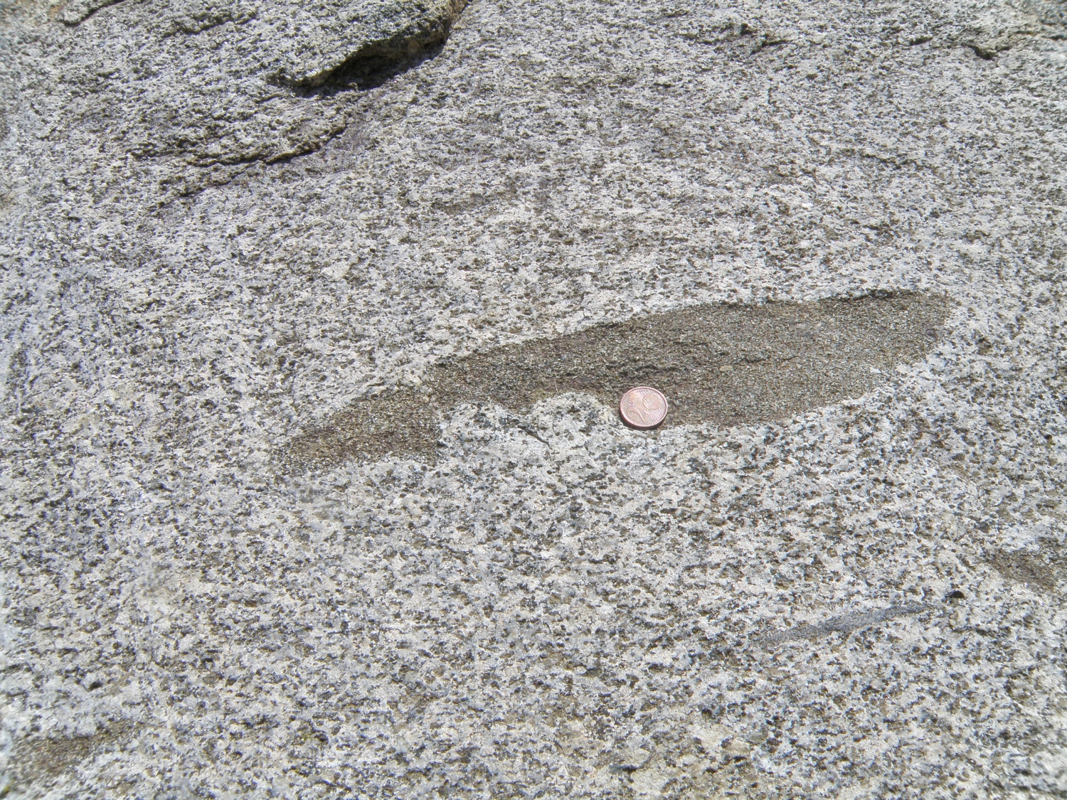 |
| Granite outcrop | Deformed xenolith |
Locality 2.
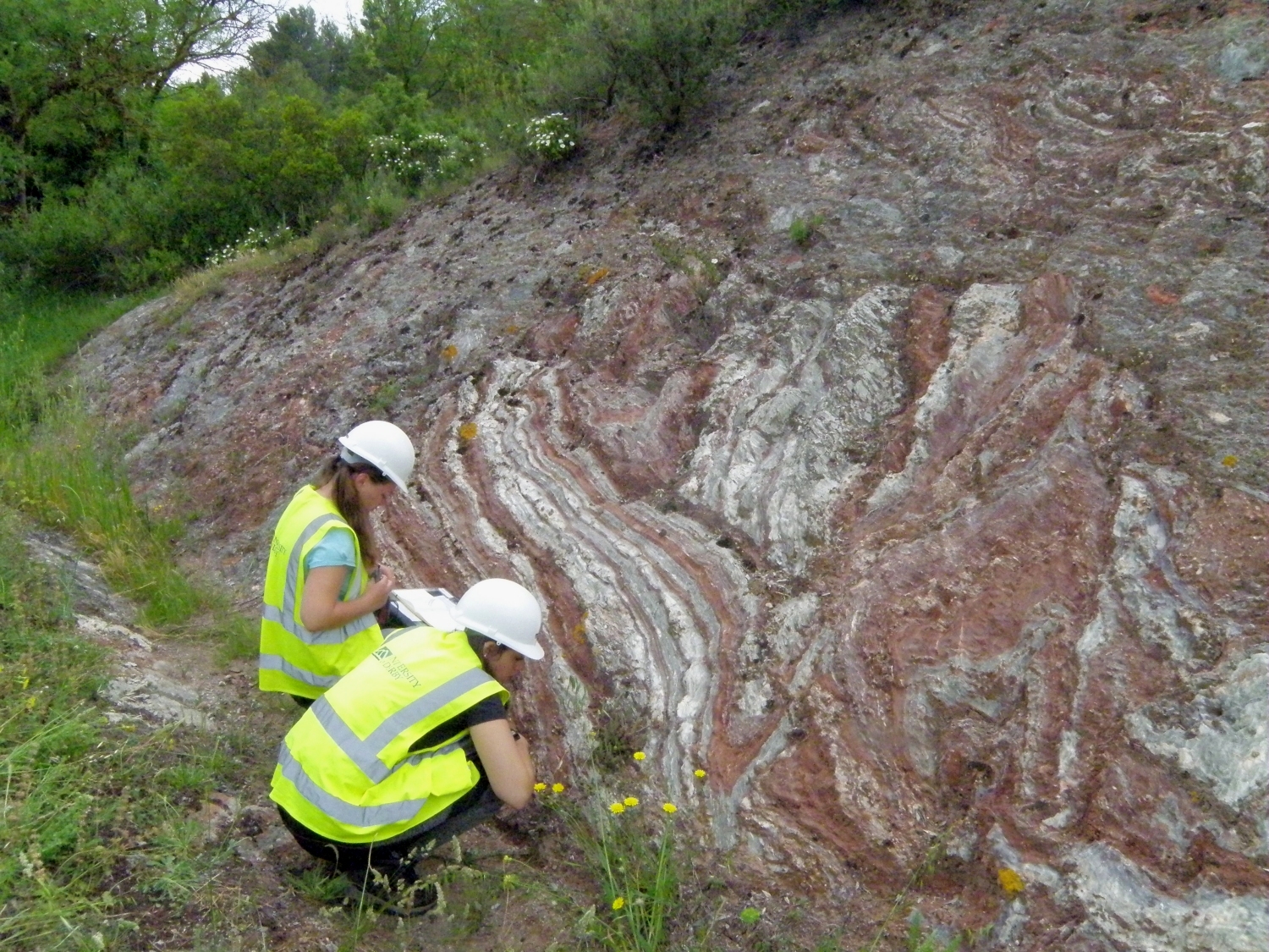
Mylonites - Gorges de la Carança (car park at 31T 0436042 4708184)
Google Maps
The gorges are located at the village of Thuès-entre-Valls, in the Carança-Canigou
Massif of the Axial Zone. A coach may drop passengers or park at the main road
(N116) entrance to the village. Cars and minibuses proceed through the village,
following signs to the main car park (payment required). In season, there is
a pleasant outdoor bar/café in the car park - La Guingette - and public
toilets. Walk to the top of the car park to start the walk through the gorges
– this is a narrow path carved out of the cliff, with easy access. It is
a popular walking route into the Canigou Massif – please allow walkers
to pass whilst you are studying the outcrops!
Most of the first part is in quartz-rich mylonites. The mylonite zone ends at the S end of the narrowest part of the gorge, some 250m from the entrance. The gabbro-mylonite contact seems to be just below the first footbridge, but exposures are lichen covered. The traverse may be continued further: at the first footbridge, the path on the E side of the stream starts to climb steeply (don't cross the bridge) on outcrops of more or less undeformed gabbro-diorite. At the top of the first steep section, these rocks contain xenoliths, and a coarse granite dyke.
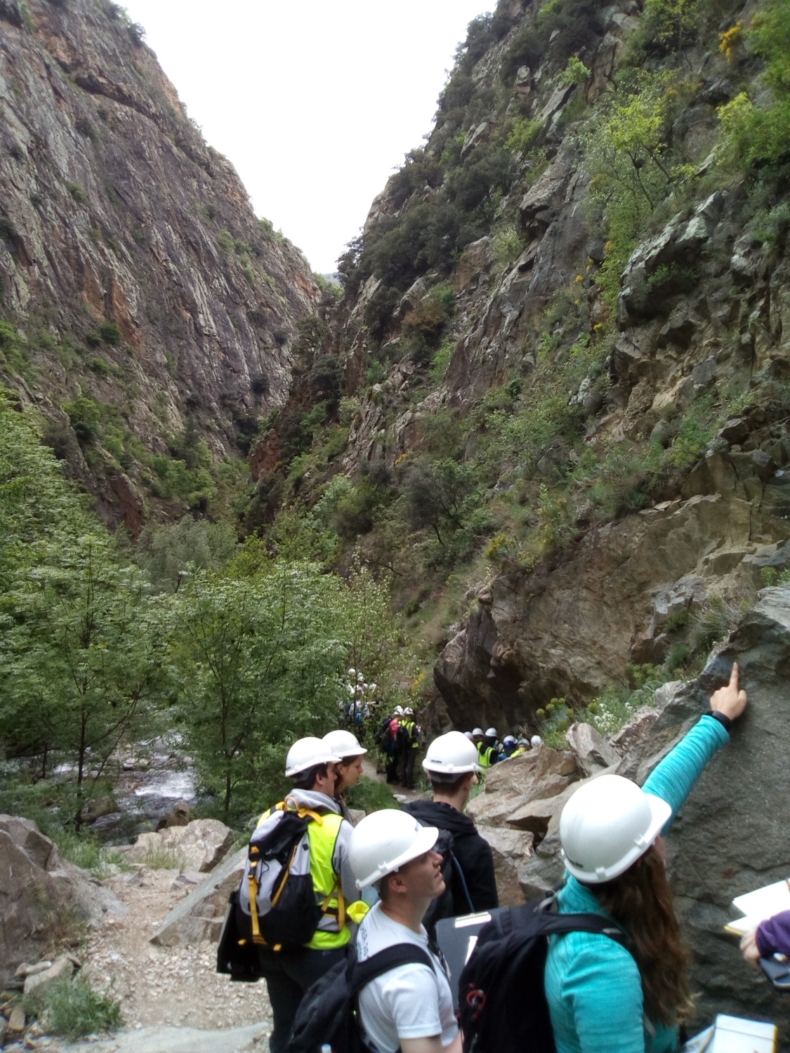 |
Left: Carança Gorges, looking N Above: mylonites |
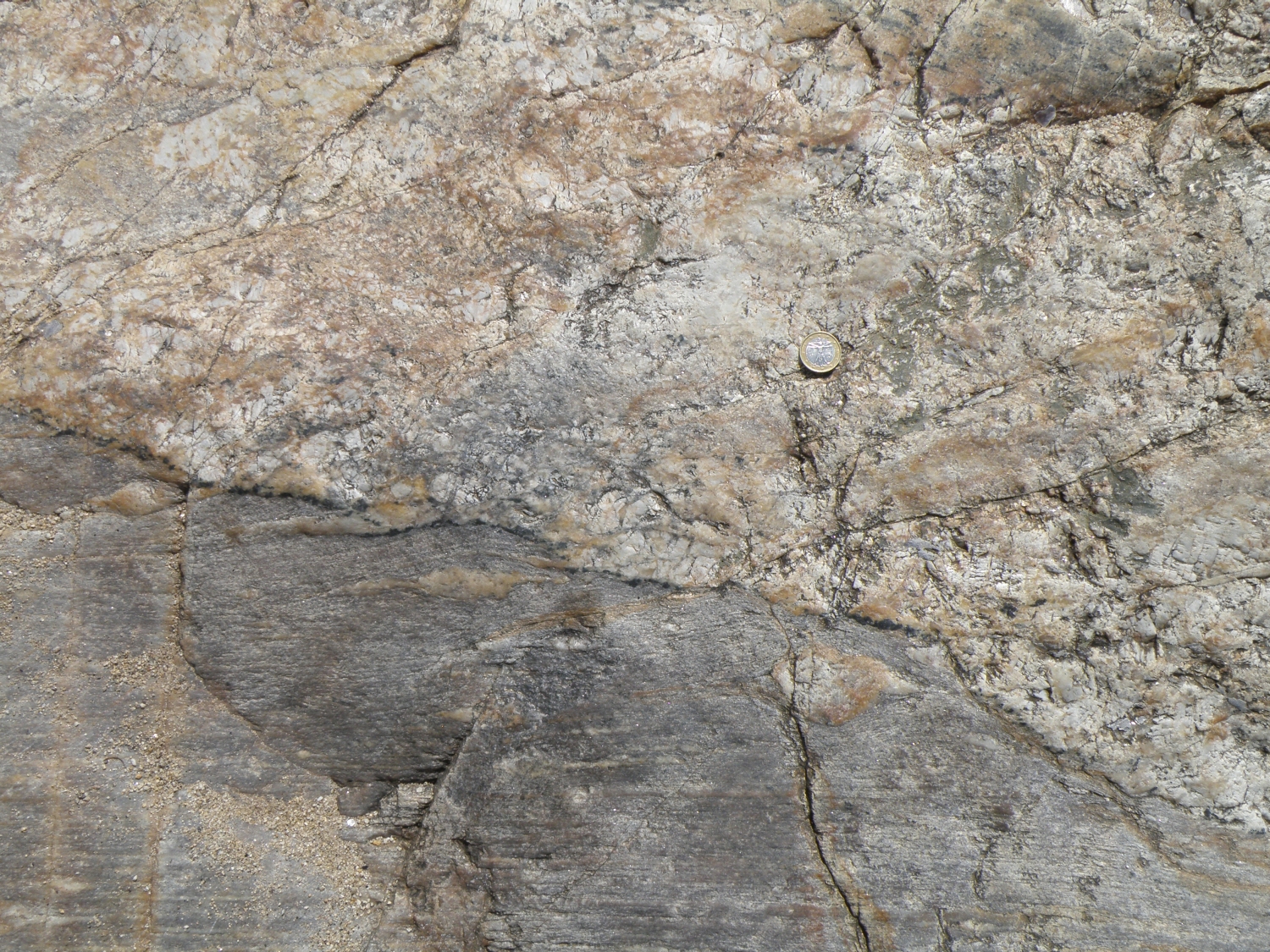
Locality 3.
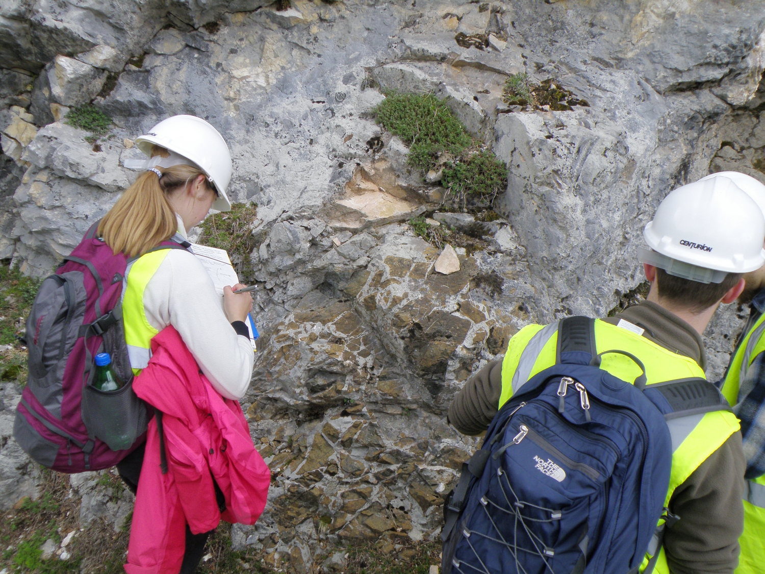
The Lers peridotites - Étang de Lers (31T 0367534 4740883) Google
Maps
This is the classic area in which to examine the Lers (formerly Lherz) peridotites,
the type locality for lherzolites. They are exposed in the North Pyrenean Metamorphic
Zone, a narrow zone just N of the North Pyrenean Fault, between the Axial Zone
to the S and the Trois Seigneurs Massif to the N.
Coaches may approach from Tarascon-sur-Ariège via the Col de Port and the village of Massat, where there are some very tight corners. Leave vehicles at the car park near the café on the NE side of the Etang de Lers. Follow the D8F road section uphill on foot for approximately 2 km to the S. There are excellent exposures of the peridotites and marbles, and the complex relationships between them, in the road cuts and on adjacent hillsides. The road zigzags across the peridotite-marble contact several times.
 |
 |
| Marble-peridotite relationships near top of section | Peridotite breccia with carbonate matrix |
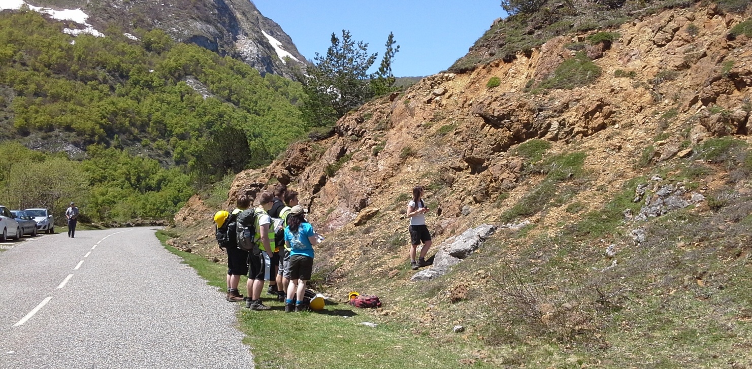
Locality 4. Metamorphic zones of the Agly Massif Google
Maps
The Agly Massif, at the easternmost end of the North Pyrenean Zone, is about
35 km in length and comprises metamorphosed Variscan basement. The main lithologies
are pelitic metasediments, gneisses and granites. The Ordovician metasediments
record a sequence of metamorphic zones, identified by index minerals.
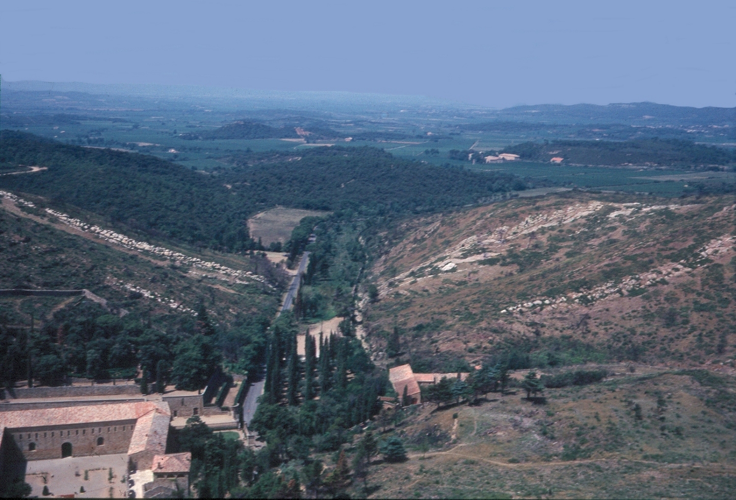
Approach from Estagel in the north or Millas in the south, via the D612. At Col de la Bataille, turn east along the minor road signposted Força Real. This locality starts at Coll del Bou (31T 0474040 4730628) (coach and car parking) where views to N and S put the Agly Massif into a regional context. To the S is the extensional Roussillon basin, and beyond it Canigou, a 2785m high mountain in the Axial Zone of the high Pyrenees. To the N, major E-W Pyrenean reverse faults emplace the Agly Massif on top of Cretaceous limestone ridges, repeated across detached synclines in the North Pyrenean Zone.
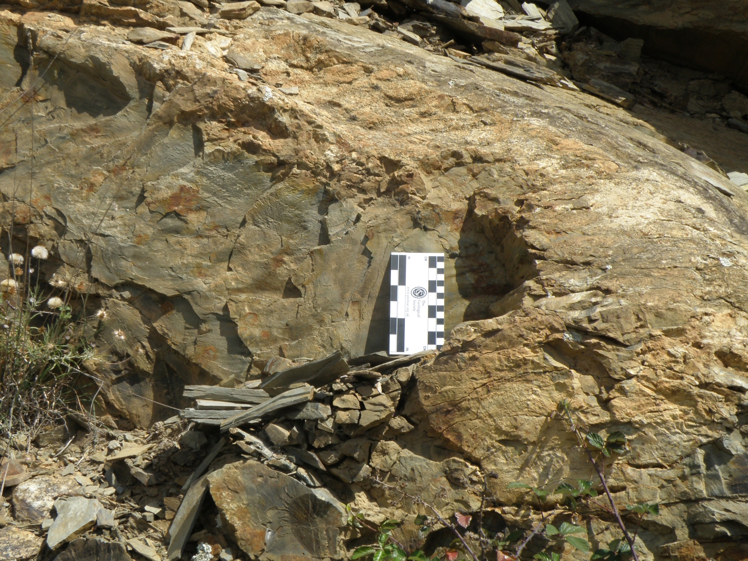
Low grade (chlorite zone) Ordovician slates can be seen eastwards along the botanic trail towards Força Real (Locality 4a: 31T 0475208 4730575). Return to Coll del Bou: along the track to the W (locality 4b), small biotite porphyroblasts in the slates indicate the biotite zone.
Drive to Col de la Bataille (Locality 4c: 31T 0472900 4730536). Now walk through vineyards to Caladroy: turn right off the D38 road at a standing stone onto a vineyard track (Locality 4d: 31T 0472591 4730449), taking a left turn at 31T 0471638 4730745: the track is way-marked. As you walk, note the increase in grain size and metamorphic grade, from slates to muscovite-bearing schists. Just W of Caladroy, D38 road cuts (Locality 4e: 31T 0470633 4729962) show migmatites with irregular quartzo-feldspathic sheets. Coach may park at Col de la Bataille, or may proceed to the end of the walk at Chateau de Caladroy to meet the group.
|
|
|
| Below left: slates in biotite zone | Below right: migmatites & granitic sheets at Caladroy |
 |
 |
Locality 5. Pyrenean tectonics S of St-Paul-de-Fenouillet
(31T 0458918 4738679) Google
Maps
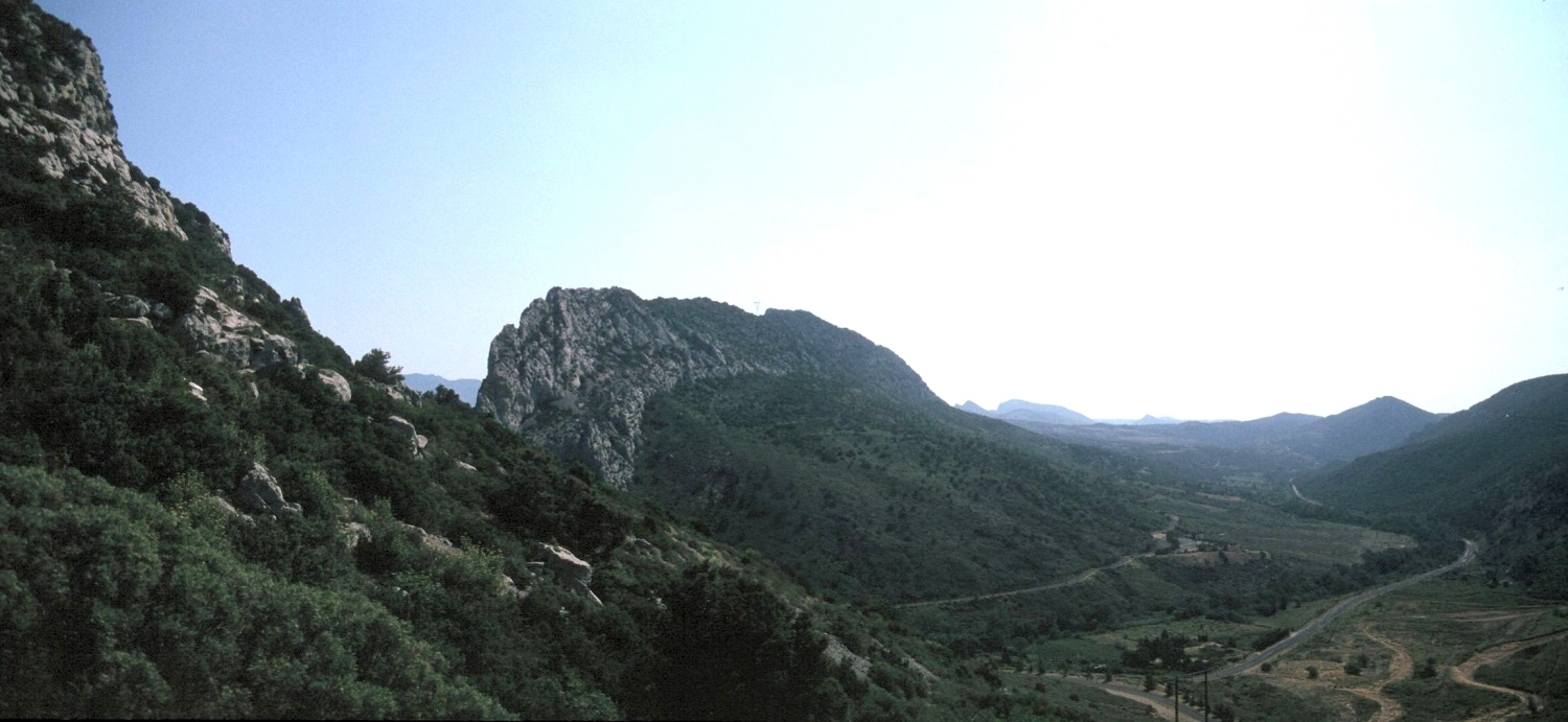
Jurassic and Lower Cretaceous limestones form thrust synclinal structures and
prominent E-W topographic ridges in the North Pyrenean zone, N of the Agly Massif.
The limestone ridges provided excellent defensive positions: note the mediaeval
Chateau de Quéribus on the ridge to the N.
The D619 S from St Paul de Fenouillet crosses the inverted southern limb of the Fenouillèdes syncline. Roadside outcrops (locality 5a) are in dark mudstones and limestones of Lower Cretaceous (Aptian-Albian) age. The inverted contact with the older massive ‘Urgonian’ limestones forming the spectacular E-W ridge is at the northern end of the gorge (Clue de la Fou) cut across strike by the Agly river. A warm water spring (24°C) emerges in the gorge (locality 5b). At the S end of the gorge, near the D619/D19 junction (Locality 5c), the limestones in the old quarries are massive and bioclastic. Along the D19 immediately S of the limestone, massive quartz is followed by a fault breccia of large granite fragments in quartz, with hematite veins. Several hundred metres SE along the D19 (Locality 5d) are outcrops of massive, weathered granite. This Variscan granite on the N edge of the Agly Massif was thrust northwards over the much younger limestone ridge during the Pyrenean mountain building. Below the south-dipping reverse fault, the limestones were folded into a footwall syncline with an inverted southern limb. Upper Triassic gypsum provided a lubricating horizon during deformation. Drive to Lesquerde, the next village E on the D19; hematite mineralization occurred later along the fault zone, and there were iron mines in and W of Lesquerde, N of the D19 (Locality 5g). Gypsum outcrops in old quarries (Locality 5e: 31T 0461530 4738464) near Lesquerde. In the entrance to the active gypsum mine, granite has been thrust northwards over gypsum (Locality 5f).
 |
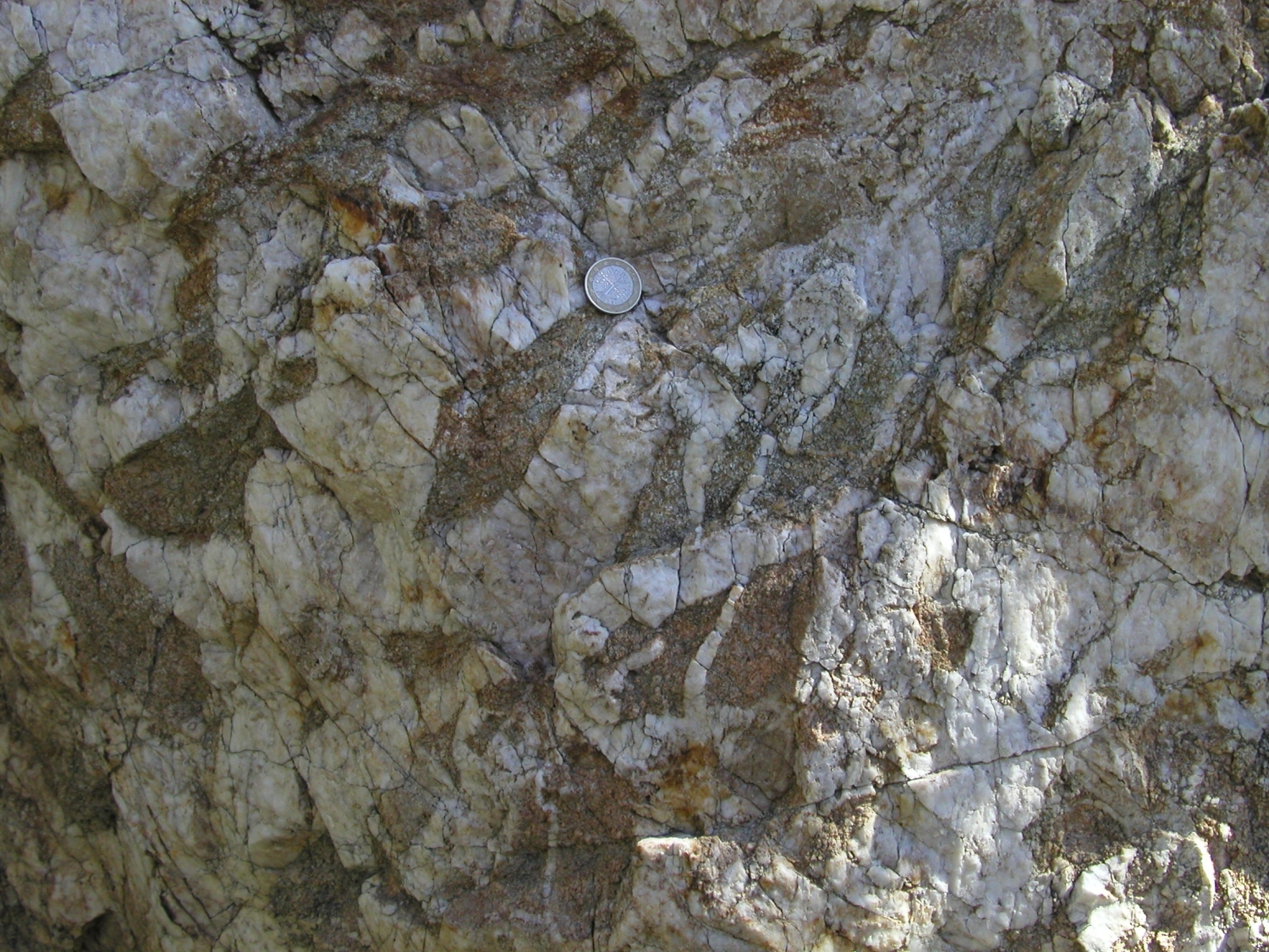 |
| View to E: limestone ridge is overturned S limb of Fenouillèdes Syncline; wooded slopes to right of limestone are overthrust Variscan granite | Fault breccia of granite fragments with quartz infill |
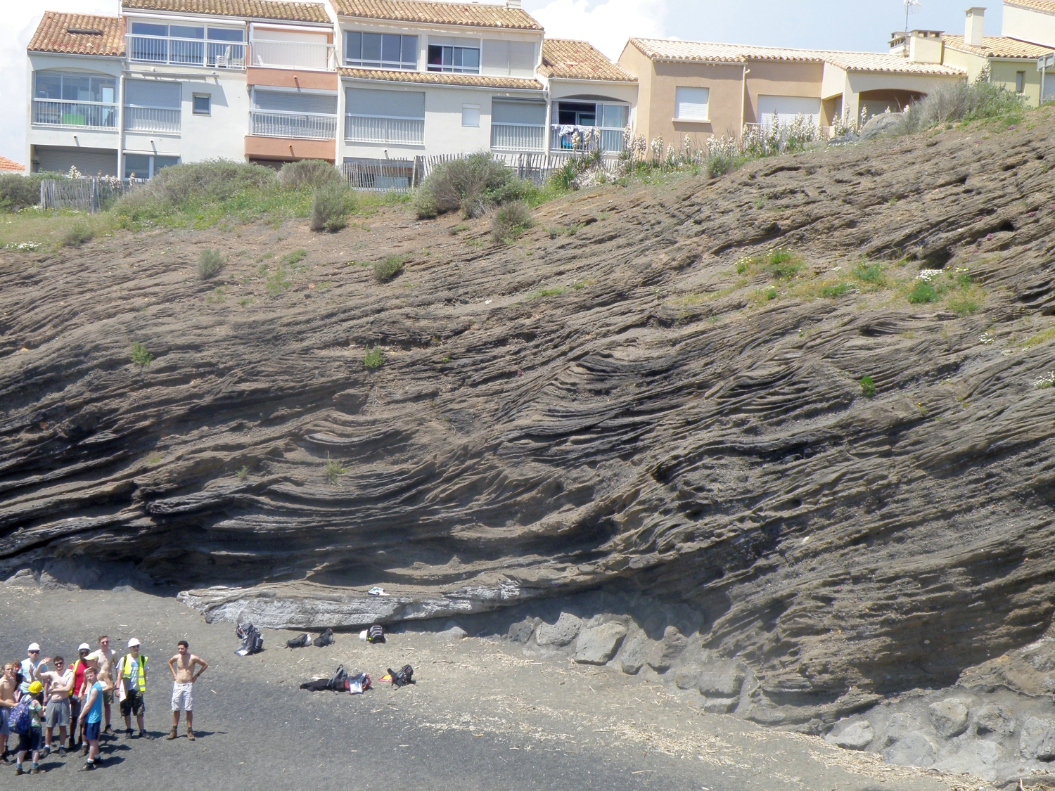
Locality 6. Deformed Upper Triassic - Durban-Corbières
(31T 0485857 4760038) Google
Maps
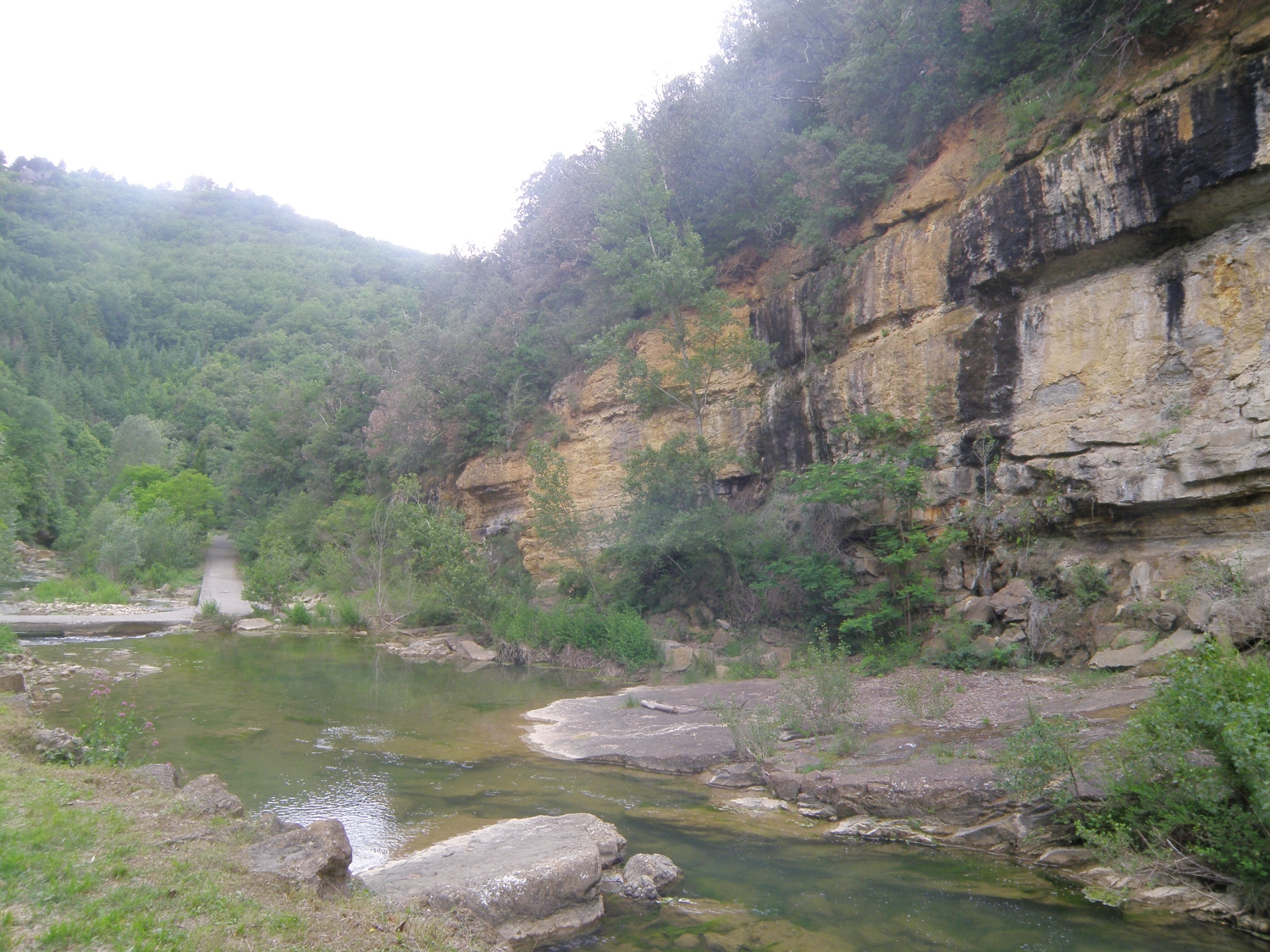
These rocks outcrop in road cuts along the D27 E of Durban-Corbières.
The outcrop is very fragile: PLEASE DO NOT HAMMER. Interbedded Upper Triassic
(Keuper) siltstones and gypsum were originally deposited in desert lakes in
a hot, arid environment. Alternating thin beds of red marl and grey-white gypsum
are cut by veins of clear gypsum (selenite). The cutting shows a range of ductile
and brittle deformation structures. These rocks provided important detachment
zones for major thrust faults in the North Pyrenean Zone: this location displays
part of the North Pyrenean Frontal Thrust, which is sub-horizontal here, and
covers a broad area of the valley N and E of Durban. D611 road cuts N of Durban
show large, mainly thin-bedded Lower Jurassic limestone blocks within the thrust
zone.
 |
 |
| Folded & faulted red siltstones interbedded with white gypsum | Detail showing folding & boudinage |
The sedimentary fill of the foreland basin from the Late Cretaceous to the Middle Eocene represents progressive erosion and unroofing of the North Pyrenees. Localities 7- 14 follow the stratigraphy in order from Late Cretaceous to Miocene.
Locality 7.
Late Cretaceous reefs - Abbaye de Fontfroide, Eastern Corbières (31T
0491585 4775211) in parking area below a prominent rocky ridge Google
Maps
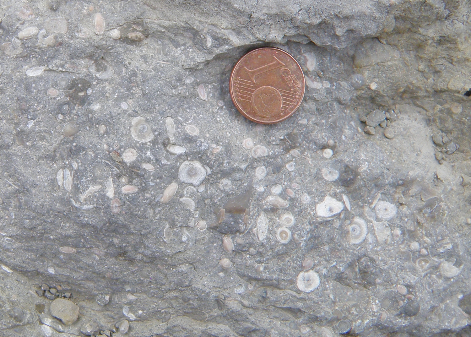
Park in the main car park. The section here represents shallow marine conditions
during the Coniacian – Santonian (Late Cretaceous: 86 – 83.6 Ma).
Thick sandstones alternate with 1-2 m thick beds of limestone containing Hippurites
rudists, unusually shaped bivalves which built reef-like structures.
Rudist reefs extend NE and SW on both sides of the car park, but are more accessible to the SW. The one closest to the abbey contains the best examples of rudists.
The Cistercian abbey is well worth a visit, and hosts concerts and other events.
 |
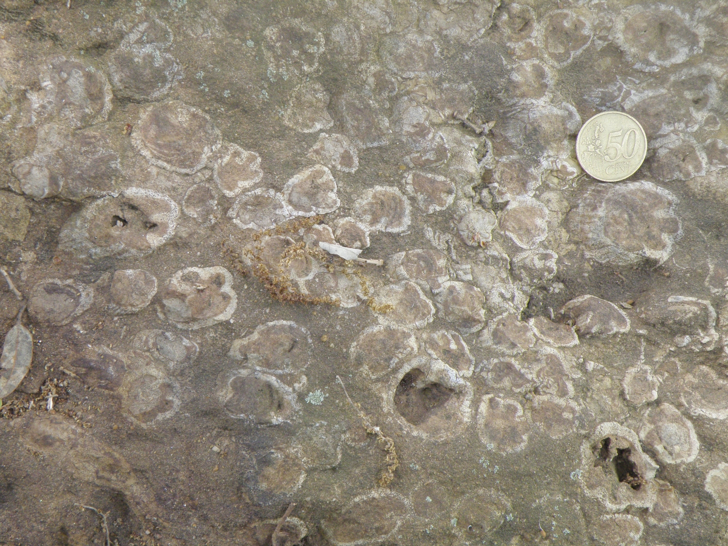 |
| Abbaye de Fontfroide, looking N to ridges formed by rudist reefs | Rudist bivalves in plan view |
Locality 8. Late Cretaceous marine basin fill - Rennes-les-Bains
(river section near swimming pool, 31T 0444528 4752384) Google
Maps
Park along the road on the N side of the village; there are designated coach
spaces. Follow the path by the swimming pool down to a small park by the River
Sals. Examine bedding surfaces in Upper Cretaceous Coniacian and Santonian limestones
and marls (86 – 83.6 Ma) in the river bed. They contain abundant shallow
marine fossils and trace fossils. Most beds are highly bioturbated.
Laterally continuous, bedded, well-consolidated bioclastic limestones with thinner marl interbeds form the river cliff (unstable!) and border the parking area.
Rennes-les-Bains is a spa town, with hot springs up to 44°C. More information
 |
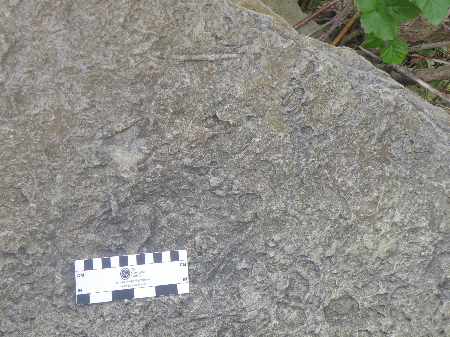 |
| Outcrops in river cliff & stream bed | Trace fossils in limestone |
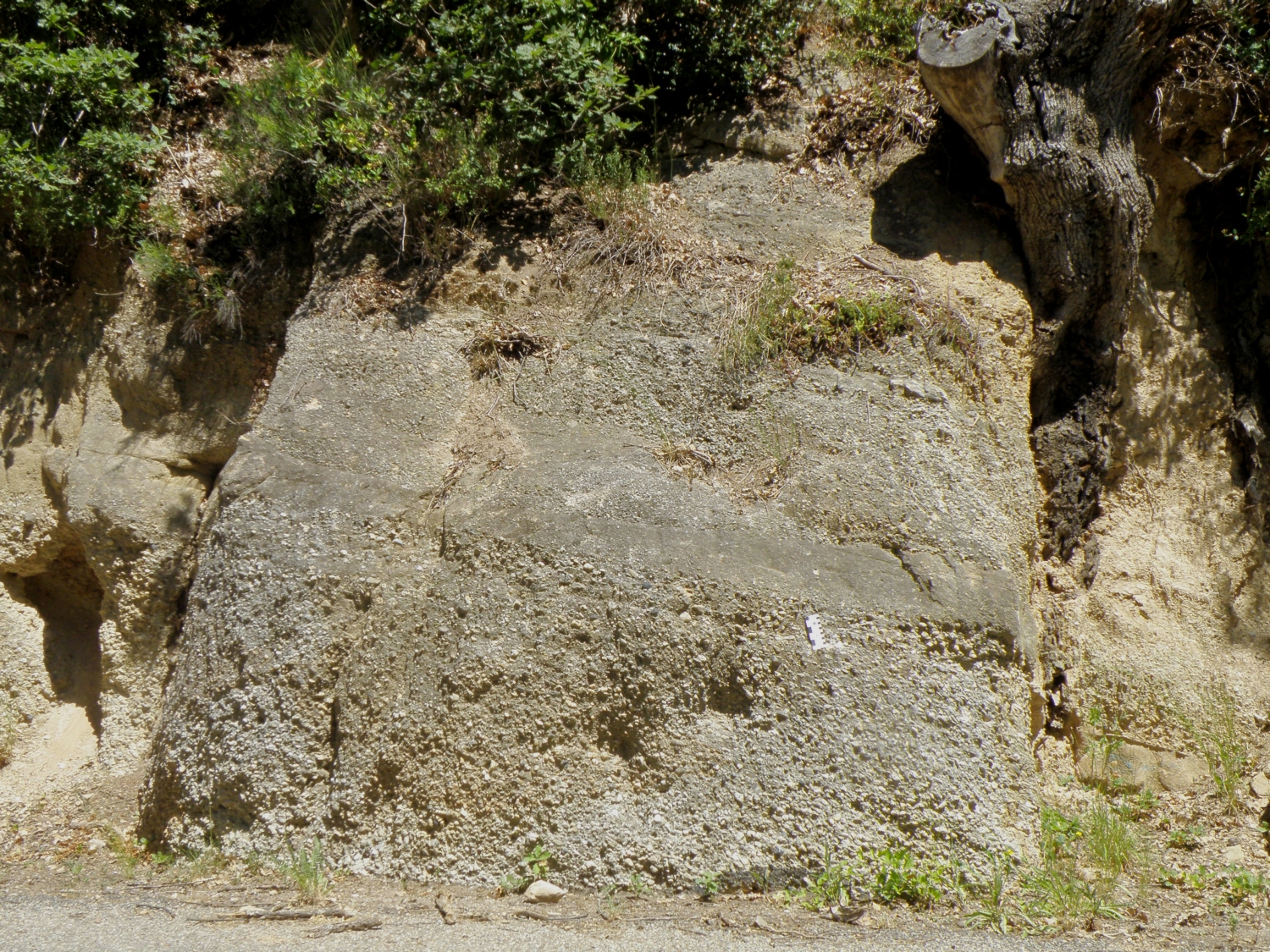
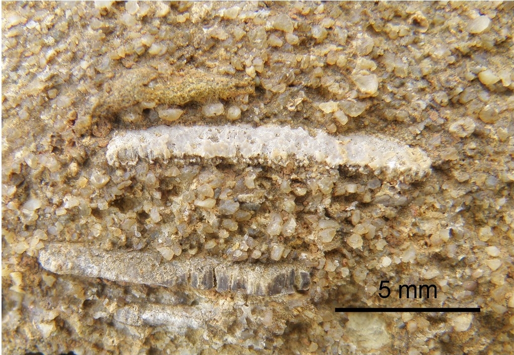
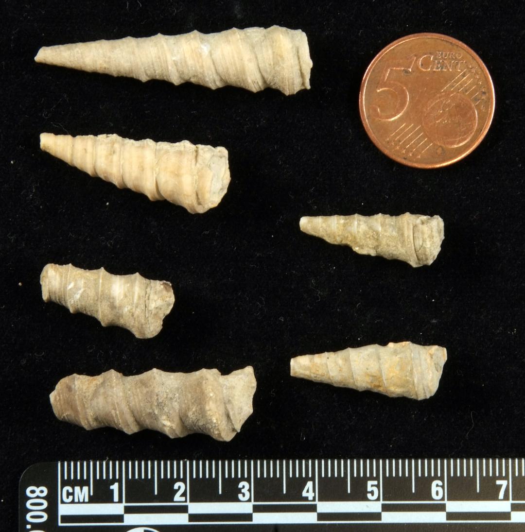
Locality 9. Late Cretaceous rivers - Alet-les-Bains
(31T 0439150 4761152) Google
Maps
Park by the river near the old stone bridge and walk to the outcrop via Chemin
des Jardiniers, then left onto Chemin des Eaux Chauds: outcrops of conglomerates
and sandstones in the Alet Sandstone Formation, of Campanian age, are in road
cuts on the right. The Alet Sandstone represents the change from marine to continental
fluvial environments in the foreland basin.
The spa town used to produce bottled water. There is still a swimming pool and a thermal establishment fed by the springs. The centre of the old village and the abbey ruins are worth visiting.
 |
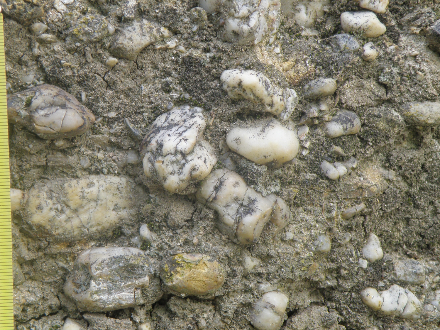 |
| Fluvial conglomerates & sandstones | Detail of conglomerate with vein quartz pebbles. Scale in mm. |
Locality 10. Late Cretaceous dinosaurs - Espéraza
and Campagne-sur-Aude Google
Maps
The excellent museum, Le Musée des Dinosaures (Locality 10a), presents
palaeontology through time, with a special focus on dinosaurs, notably those
found in the Upper Cretaceous of the Upper Aude Valley. Groups and individuals
can book tours of the museum and of an excavation site through the website www.dinosauria.org/fr/
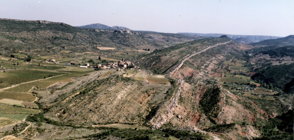
The Campanian-Maastrichtian section at Campagne-sur-Aude: the steep road past the Salazar winery climbs through soft Campagne Marl to a small sandstone cliff (Locality 10b) on a left-hand bend. Look SE across the valley, where the same sequence is exposed (see annotated photo below). Near the top is a prominent white cliff of lacustrine limestone up to 20m thick (Vignevieille Limestone), divided by a thin marl (visible notch) corresponding roughly to the K-T boundary. To the S, the higher hills around Quillan are of Lower Cretaceous limestones in the North Pyrenean Zone, thrust northwards over the late Cretaceous-Paleocene basin fill.
The sandstone cliff is a good exposure of the Estous Sandstone. At its base, colour-mottled siltstones represent a palaeosol (fossil soil) at the top of the Campagne Red Marl. The sandstone outcrop represents the infill of a river channel; cross-bedding, dinosaur egg shell and bone fragments can be found, but this is a site of special scientific significance, so please DO NOT HAMMER THE OUTCROPS.
Above is the rather poorly exposed Maurine Red Marl. The lower part has been excavated for dinosaur remains.
 |
 |
 |
Above left: late Cretaceous - Paleocene stratigraphy seen across the Aude valley. Stratigraphic column courtesy of Romain Liard. Above right: fluvial channel in Estous Sandstone. Dorothy for scale. Left: dinosaur egg shell fragments in sandstone |
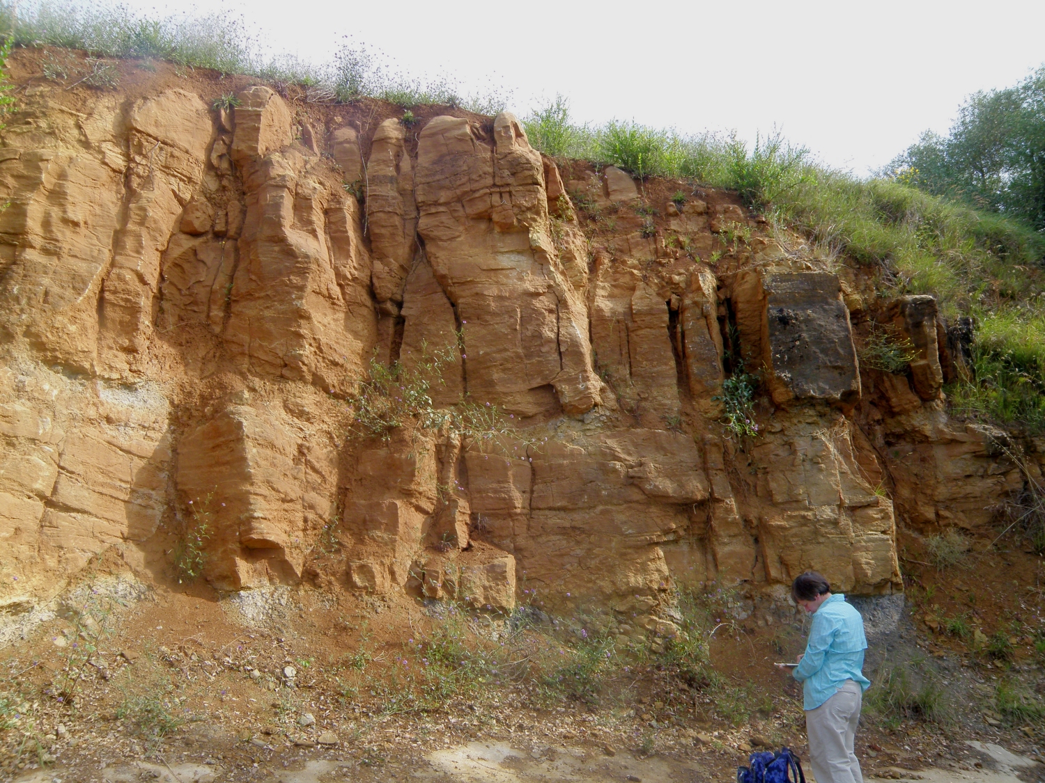
Locality 11. Continental sediments across the K-T boundary
- Albas Ridge (31T 0478528 4761210), Eastern Corbières Google
Maps
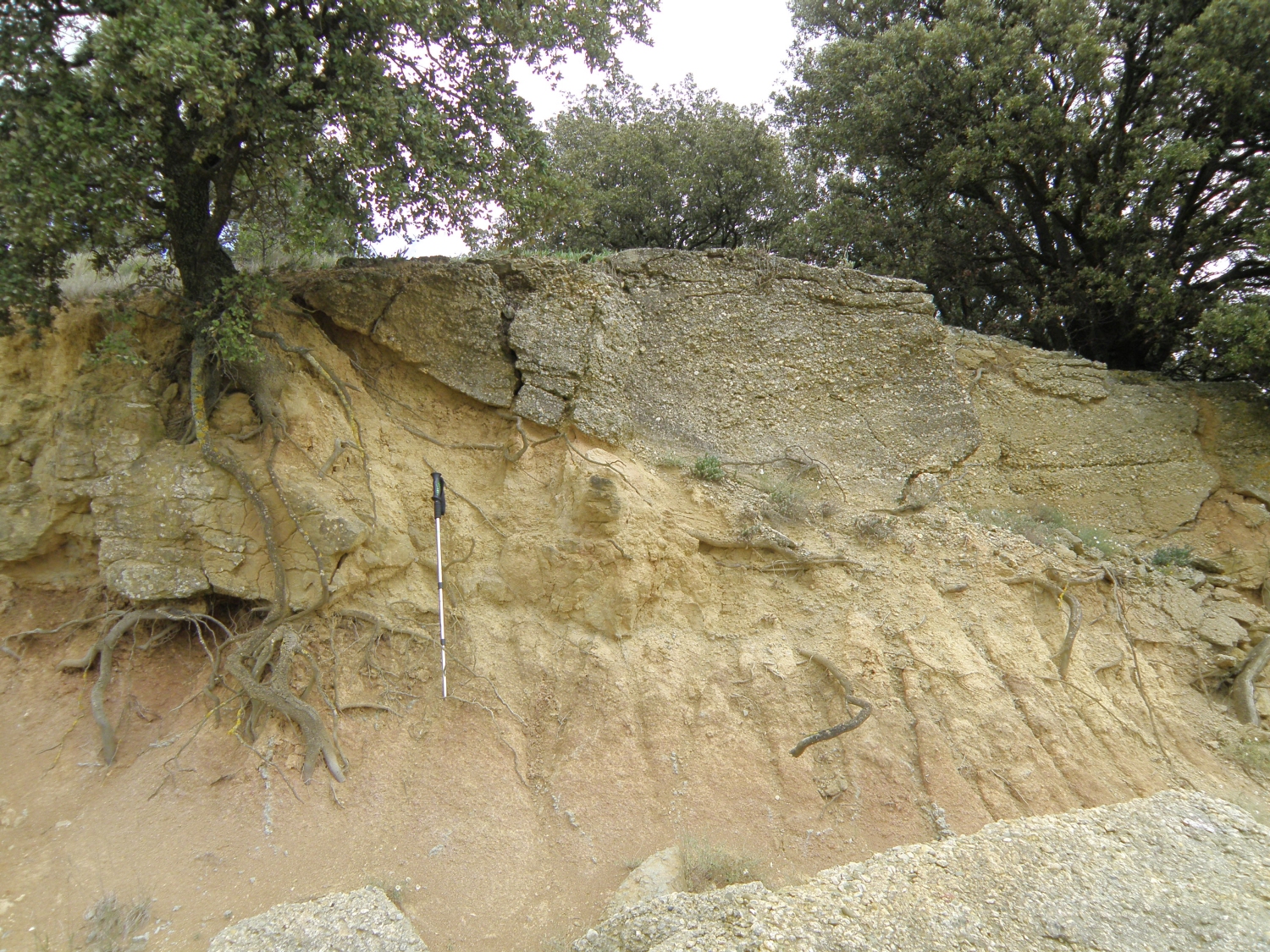
Late Cretaceous – Paleocene continental sediments can be studied in a laterally
continuous, well-exposed section. Park in the layby at the S end of the section.
At the layby, in the centre of the village, and elsewhere, the geology is explained
on interpretative signs: “La
Rando du Géologue” (The Geologist’s Walk). Walk N on the
D106, and at a left-hand bend, take a vineyard road on the right. The walk up
the S side of the ridge will take about two hours. Take care - it is easy to
slide on loose scree. The outcrops on the W side of the D106 are less steep
and it is possible to climb more easily through the stratigraphy.
Bright orange, poorly consolidated siltstones & sandstones of uppermost Maastrichtian age (68 – 66 Ma) underlie the valley vineyards. Mottled sediments with root traces suggest soil formation on a flood plain. Sharp-based lenses of sandstone and/or conglomerate represent small river channels. These persist up much of the slope, into the Paleocene. Harder nodular limestones are calcrete palaeosols.
The Cretaceous-Paleogene (K-T) boundary occurs in the lower slopes, but its exact position cannot be determined. Higher up the slope is a laterally continuous lacustrine limestone bed 3-10 m thick with a conglomeratic base. Further north, near the crest of the ridge just S of the village, a marl with marine fossils, 3.5 m thick and of Thanetian age, represents a short-lived marine incursion from the west.
 |
|
|
Above: aerial view of the Albas ridge, looking E Below left: titanosaurs roam the hills just below the K-T boundary! |
Below right: sharp-based fluvial channel conglomerate; palaeosols beneath. |
 |
 |
Locality 12. Eocene marine sediments and fossils - Coustouge
to Jonquières road section (from 31T 0478803 4766023 to 31T 0477893
4765866) Google
Maps
Start the section on the D323, 150m W of the D106 junction in Coustouge, and
ascend the road towards Jonquières. The earliest Eocene (56 – 48
Ma ) or ‘Ilerdian’ sediments are limestones and marls, often bioturbated,
with abundant shallow marine fossils. Sandstone units may show laminations,
wave-ripples, cross-bedding or soft-sediment deformation.
Overlying this section on the hillside W of the 2.0 km marker, fluvial sediments of Lutetian age outcrop – the ‘Molasse de Carcassonne’.
 |
 |
|
Above: wave ripples in sandstone Top right: large benthic forams & mollusc debris in limestone Right: turritellid gastropods |
 |
Locality 13. Eocene river channels - Aigues-Vives (31T
0462034 4786146) and around St Jean (31T 0461781 4787298) Google
Maps
Early to Middle Eocene sediments (Lutetian: 47.8 to 41.3 Ma) form raised ridges
of sandstone and conglomerate around Aigues-Vives. They are several metres wide
and can be traced for tens to hundreds of metres. They are interpreted as fluvial
channels, whilst red soils in the intervening vineyards represent finer flood-plain
deposits with palaeosols. Some channel margins show clear erosive contacts with
underlying flood-plain sediments. Numerous small quarries exploited the sandstones
to build the mediaeval city of Carcassonne: a visit to the Cité to see
the use of these building stones makes a good complement to this locality.
A single straight channel is clearly seen along the D57 S of Aigues-Vives (Locality 13a). A complex network of channels can be followed through the vineyard roads around St-Jean, N of Aigues-Vives (Localities 13b). This makes for an interesting mapping exercise, encouraging students to think about connectivity within sandstone aquifers or petroleum reservoirs.
 |
 |
| Sandstone channel; edges collapsed due to undercutting of the soft flood plain sediments beneath | Cross section of conglomerate-filled channel cutting into finer floodplain deposits |
Locality 14. Miocene sediments and archaeology - Malpas
and Oppidum d'Ensérune (Malpas Tunnel 31T 0510318 4794993) near Nissan-les-Ensérune
Google Maps
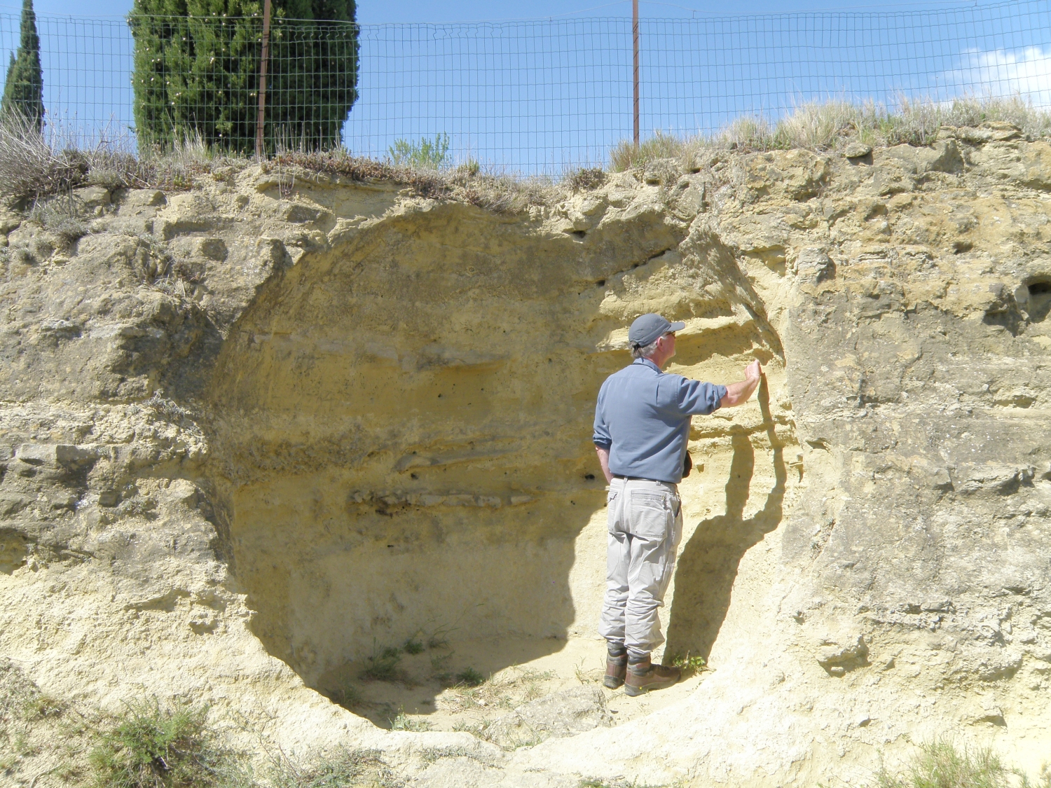
Near the Maison du Malpas Tourist Centre, a path and steps descend to the N portal of the Canal du Midi tunnel (locality 14a). There are shallow marine Miocene limestones and marls on the opposite side of the canal. They are convoluted indicating soft sediment deformation shortly after deposition, perhaps as result of earthquake activity.
On the drive or walk W along the road to the archaeological site at Oppidum d’Ensérune, good exposures of Miocene bioclastic marine limestones are seen. Storage silos from ca. 600 BC were carved into the rock and one was later bisected by the road (Locality 14b). Don’t miss the view N over the drained lake of Montady, and a visit to the Oppidum site.
The Canal du Midi is part of a major civil engineering project to link the Mediterranean to the Atlantic in the time of Louis XIV. More information
 |
 |
| Malpas Tunnel: disturbed Miocene sediments | Oppidum d'Ensérune: cross section of storage silo cut in Miocene limestones. Hugh for scale. |
Locality 15.
Variscan gneisses and intrusions - Gorges d’Héric (Car park,
snack bar and toilets at 31T 0497372 4824527) Google
Maps
Variscan basement of the foreland is exposed N of the Aquitaine-Languedoc Foreland
Basin in the S Montagne Noire. The Gorges d’Héric are at the eastern
end of the Montagne Noire Axial Zone, which is in fault contact to the S with
southerly verging recumbent folds made up of sedimentary rocks of Palaeozoic
age. The Gorges d’Héric outcrops are part of the Caroux gneiss dome.
Walk N from the car park along the road into the gorge. Schists are exposed in road cuts on the left (Locality 15a). At the concrete ‘Bridge of Sighs’ (Pont des Espirs: Locality 15b: 31T 0497285 4824732), the geology is very complex, but beautifully exposed in river-washed outcrops. Note cross-cutting muscovite pegmatites with large black tourmaline crystals and some huge white feldspar crystals. These pegmatites cut a complex suite of intensely foliated augen gneisses and more massive units. More massive, quartz-rich, units occur as concordant bands within the gneisses. Similar relationships are seen by continuing the walk along the road up the gorges. The steep-sided gorge suggests rapid recent uplift and downcutting.
 |
 |
 |
Above left: Gorges d'Héric, cut into the Caroux gneiss dome Above right: complex metamorphic-igneous relationships Left: granitic intrusion crosscuts gneisses |
Locality 16.
Basaltic volcanoes - Cap d’Agde Google
Maps
Numerous young alkali-basalt volcanoes, in N-S alignment, occur in the region
N and E of Béziers. One of the best exposed is on the coast at Cap d’Agde,
at the beaches S and E of the aquarium (La Plagette 31T 0541503 4791413 to La
Grande Conque, 31T 0541920 4791705). The breakwater at the S end of the section
is composed of fresh blocks of alkali basalt containing sparse mantle peridotite
inclusions. The cliffs behind both beaches show sections through a tuff ring,
with cross-bedded pyroclastic surge deposits and bombs. This indicates interaction
of basaltic magma with water, probably seawater, causing violent explosions
like those seen at Surtsey in 1963.
 |
 |
| Cross section of tuff ring, La Plagette | Climbing dunes in pyroclastic surge deposits, La Grande Conque |
Further Reading: see the Geology Today article
Additional localities will be added to this web site later.
![]()
![]()
This page is maintained by Roger Suthren. Last updated 24 November, 2022 4:03 PM

