INTRODUCTION TO ALASKA'S VOLCANOES


Diagram showing Alaskan subduction zone

Image courtesy of U.S. Geological Survey AVO

PLATE TECTONICS

Geologically the Alaskan province in North America represents a modern tectonic fold belt that has been evolving since the middle of the Cretaceous period (Howell, 1995) and has resulted in the accumulation and accretion of many pieces of continental crust over time.

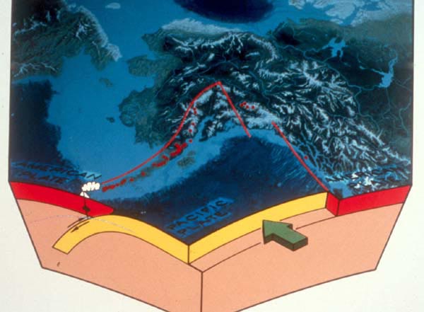
The accretion of these terrains led to the development of a subduction zone where the Pacific Plate underthrusts below the North American Plate (Crossen, 2001), this can be seen diagrammatically in figure 1. The red line represents the line of volcanoes down the Alaskan peninsula while the thick red block is the North American plate and the yellow block the Pacific plate.

As the Pacific plate sinks it begins to heat and melt forming the liquid magma that rises up and forms the chain of volcanoes. In the more Northern and Central areas of the subduction zone rates of subduction are relatively fast at 6-8cm per year therefore volcanoes situated on this portion are more active (Crossen, 2001) than those to the south where subduction rates are slower.

Subduction related volcanoes tend to be stratovolcanoes that have steep sides near the vent but gentler slopes near the base

Alaska contains numerous volcanoes and volcanic fields that total in excess of one hundred and these have been active in the last 1.5 million years. The majority of these volcanoes and volcanic centres are located within the Aleutian Arc with the exception of the Wrangell volcano (Author unknown, 1998). The Aleutian Arc forms part of the Pacific Ring of Fire.

Alaska's volcanoes on average produce in the region of 1 to 2 eruptions per year and 20 major eruptions have occurred in the last ten thousand years. Records of the eruptions first began back in 1760 when the Russians landed on Alaska's shores and began to explore its southern coasts however many eruptions probably went unrecorded as records were intermittent (Miller et al, 1998). Alaska's volcanoes can be split into two main provinces; in the west are the Cook Inlet Volcanoes while in the East are the Wrangell Mountain group. A distance of 400 miles separates these sets of volcanoes.

Image courtesy of U.S. Geological Survey AVO

The Cook Inlet Volcanoes

These volcanoes are located on the Alaskan Peninsula and they are the result of a low angled subduction zone as their location is 320km away from the subduction trench. Geologically the volcanoes are quite young being less then 1 million years old. The volcanoes in this area are called Hayes, Mount Spurr, Mount Redoubt, Mount Illiamna and Mount Augustine, these are listed from a northerly to Southerly location and Mount Augustine is the youngest of the group at 19,000 years old (Snyder, 2000)..


Wrangell Volcanoes

These volcanoes are the result of the Subduction of the yakutat terrain under Alaska. These volcanoes are very different to those of the Cook Inlet and aren't as active. The last eruption was from Mount Wrangell some 1300 years ago and modern activity consists of steam coming from the vents. These volcanoes are dome shaped and when active produced fluid lava (Snyder, 2000). The volcanoes are called Mount Blackburn, Mount Bona, Capital Mountain, Mount Churchill, Mount Drum, Mount Gordan, Mount Jarvis, Mount Sanford, Tanada Peak and Mount Wrangell.

Map Showing Wrangell Mountain Volcanoes

Image courtesy of U.S. Geological Survey AVO


HOME    FIELDTRIP    LINKS