The Sherwood Sandstone Group is thought to have been deposited
from ephemeral braided streams in a hot continental semi-arid to arid environment
with periodic vegetation cover - most probably trees and shrubs - growing
on the stable banks of channels (Root pedogenic structures can be recognised
within the Otter Sandstone Formation).
| Sediment supply for the Sherwood Sandstone Group was probably derived from a source in the south - which is shown in the palaeocurrent data - following early Permian subsidence controlled by faulting. This is supported by trough cross bedding which indicates that the sediment source is perpendicular to the E/W trending outcrop. |
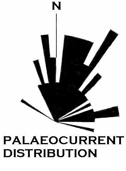
Palaeocurrent distribution within the Otter Sandstone
Formation.
|
The 4 main facies associations are:
![]() Fluvial deposits
comprising of fining upward sequences with cross bedding.
Fluvial deposits
comprising of fining upward sequences with cross bedding.
![]() Floodplain deposits
from flooding events generating ephemeral lacustrine conditions and depositing
a fine suspended sediment load.
Floodplain deposits
from flooding events generating ephemeral lacustrine conditions and depositing
a fine suspended sediment load.
![]() Aeolian dunes
that were deposited away from the main fluvial systems and in interfluvial
areas, which consist of reworked sediment from the rivers.
Aeolian dunes
that were deposited away from the main fluvial systems and in interfluvial
areas, which consist of reworked sediment from the rivers.
![]() Palaeosols indicated
by sinuous vertical calcretes and calcrete sheet like structures.
Palaeosols indicated
by sinuous vertical calcretes and calcrete sheet like structures.
| Conglomerates at the base of F1
and F2 maybe the consequence of high initial
flow, reworking of surface deposits and initiation of new channel systems.
Episodic high flow resulted in erosion of the bank.
The complex lateral as well as vertical variation within the outcrop suggests transport and deposition by braided river systems. Rare occurrence of non-marine vertebrate fossils and the absence of marine fossils and wide spread occurrences of anhydrite, development of calcretes, desiccation cracks and deflation surfaces with ventifacts (Holloway, 1989). These features may have developed from ephemeral lakes or floodplain environments. These arid conditions resulted in the oxidization of the sediments giving them their distinctive red coloration. Dolomitization is thought to have taken place in a sabkha or playa environment. Isotropic evidence suggests that the aridity and groundwater discharge is typical of continental sabkhas (Bath, 1987). |
Desiccation Cracks within the Otter Sandstone Formation showing infilling from the unit above. (Photo from Jonathan Redfern, 1999) |
Aeolian deposits are recognized by their lack of cross bedding and grain grain analysis, which both indicate a non-fluvial depositional environment.
The surface texture of the quartz sand grains from the lower Triassic unit are almost identical to the sands from modern hot deserts suggesting a similar environment. The sample studied comes from the base of the Otter formation. (Krinsley et al, 1976)
There are 4 main textural features of quartz grains from a modern hot desert.
1 - upturned plates covering the surface of larger grains, where the grains have had high velocity collisions when saltating. High velocities are a result of wind transport as grains reach much higher velocities than similar grains in water. The plates are from resulting cleavage scraps.
2 - equidimensional or elongate depressions, which are a result of direct instead of glancing impacts between saltating or creeping grains.
3 - smooth surfaces on smaller grains due to precipitation and solution of silica. These grains are generally unaffected by abrasion as the grains are transported by suspension, when collisions occur they is less abrasion due to low kinetic energy levels.
4 - arcuate, circular or polygonal cracks on smaller grains
as a result of physical or chemical weathering.
Coastal aeolian grains show a smaller amount of upturned
plates, but other signs are rarely found on coastal grains and are common
on hot desert aeolian grains.
All four characteristics are found on both the Triassic
grains and the modern hot desert grains.
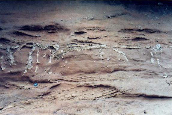
Photo showing a layer with calcretes.
|
Palaeosols within
the Otter Sandstone Formation are represented by carbonate precipitation
around taproots of phreatophytic plants and rising water tables (Purvis
& Wright, 1991).
Calcretes are formed from the cementation of calcium carbonate and are a prominent feature in climatic zones where a seasonal moisture deficit occurs allowing the CaCO3 to accumulate. Palaeo-calcretes have been described from two distinctive settings, alluvial/lacustrine and shallow water carbonate systems. (Wright and Tucker, 1991) |
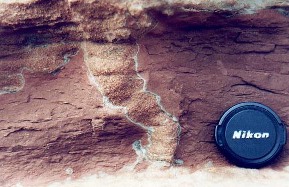
Close-up of rhizocretions within the Palaeosols. (Photo from Jonathan Redfern, 1999) |
Evapotranspiration is a major process in semi-arid calcretes
and a major cause of rhizocretion formation.
Rhizocretions are accumulations of mineral matter around the roots of the plants, these are accompanied by cementation, which may occur during the life or after the death of the plant roots. Aerial roots or former vegetation may have decomposed or been eroded, whereas the subterranean root system remains (Wright and Tucker, 1991). These rhizocretions and sheet like structures formed below the surface therefore increasing their preservation potential. Rhizocretions within the Otter Sandstone Formation are up to 2m in length and up to 0.15m in diameter. They reflect the colonization of sandy groundwater aquifers by phreatophyte-like plants. These areas are interpreted as being episodes of vegetation cover on wind blown sand patches. The depth of the roots is indicative of taproots, which penetrate deep into the sediment to reach the main water table; these plants are typical of semi-arid to arid channel-bar or floodplain deposits. The types of plant responsible were probably trees. |
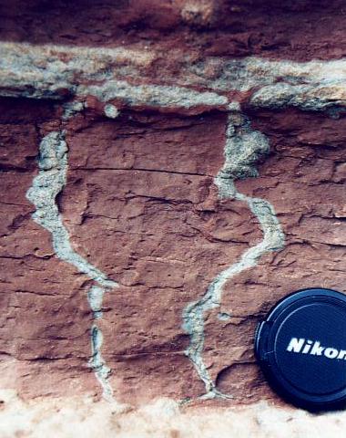
(Photo from Jonathan Redfern, 1999) |
Groundwater cementation is common in arid and semi-arid alluvial settings. The sheet like structures are thought to have originated at or just above the water table in the capillary fringe zone. The occurrence of numerous sheets shows the episodic rises in the water table as the sediment surface was aggraded. |
The Sherwood Sandstone Group shows that climate exerted a significant control on the alluvial architecture of this braid plain system, which was dominated by random channel avulsion (McKie et al, 1998).
![]() A base
level rise is shown by lacustrine deposits and fine-grained mud-rich floodplain
deposits.
A base
level rise is shown by lacustrine deposits and fine-grained mud-rich floodplain
deposits.
![]() A base
level lowering resulted in fluvial incision, which was generally shallow
and wide.
A base
level lowering resulted in fluvial incision, which was generally shallow
and wide.
There was an increase in sand deposition during these
dry climatic conditions when sediment yield increased as a result of devegetation,
but with sufficient runoff to maintain fluvial sediment transport. Aeolian
transport during the driest conditions probably produced local sediment
recycling.
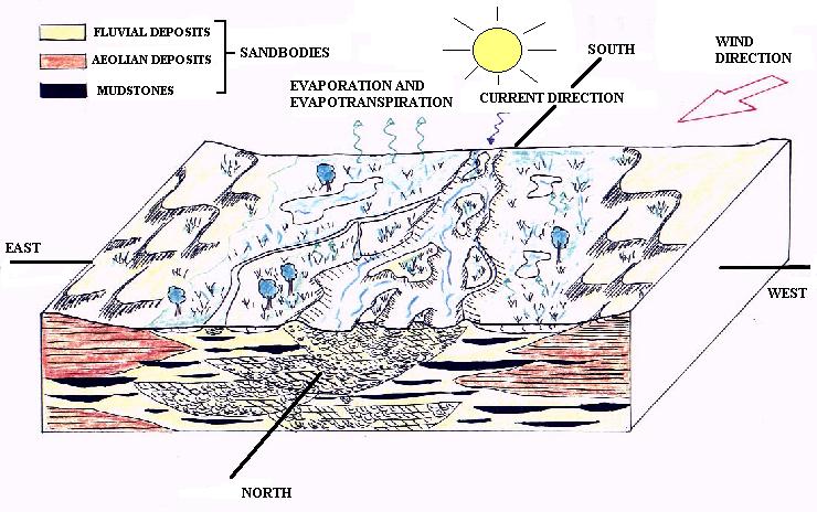
Schematic interpretation of the depositional environment
of the Otter Sandstone Formation at Anisian times. Vertical scale exaggerated.
(Lacroix, 1999)
![]()
 |
Page constructed by M. Wheeler
Copyright © 2000 Mark J Wheeler